
Cyclades
Antiparos
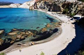
 Antiparos is a small Cycladic island situated to the west of Paros, separated by a wide channel of 500 meters to 1,000 meters. Its unique village of sparkling white, its small port lined with restaurants, and its many beaches make its charm. The cave is the main center of tourist interest of the island.
The Marquis de Nointel, ambassador of Louis XIV in Constantinople, for a long time forgotten, made it famous in 1673. He decided to have the Christmas Mass celebrated by installing an altar on one of the most impressive stalagmites, practically 90 m underground.
He engraved his name and date to commemorate the event. It was south of Antiparos, on and around the islet of Despotiko, that Theodore Bent discovered the first known and proven traces of the Neolithic Cycladic civilization.
– Visit of the old village, Kastro
– Visit the cave.
Amorgos
 The easternmost island of the Cyclades. It has two ports on its west coast: Katapola in the center and Órmos Aighialis (or Aighiali) in the North. The capital, called Chora or Amorgos, is located at an altitude of 320 meters.
The island is more or less divided into three poles regrouping several villages:
– Egiali in the North (Langada, Tholaria, Potamas, O.Eghialis)
– Katapola and Chora in the center
– The kato meria in the south.
The island is famous for its Chozoviotissa monastery hanging on the cliff.
It acquired a new notoriety with the film Luc Besson Le Grand Bleu, some of which were filmed in 1987 in Chora and at the foot of the monastery of Chozoviotissa.
Do not miss:
All the villages, the monastery, the mount minoa at sunset, excursion in the small Cyclades.
Anafi
 Situated at the extreme south-east of the Cyclades archipelago, Anafi Island is the furthest from Athens. Its surface area is 37.5 km2. It is 582 meters high and has 273 inhabitants. It is also one of the wildest islands of the Archipelago.
Anafi is located to the east of Santorini and about 1 and a half hours by boat. The island has remained calm and continues to be an ideal place for relaxation. The legend says that the island would have been created by Apollo so that the Argonauts can rest on the way of the Golden Fleece. With the exception of the port of Agios Nikolaos, consisting of a few houses,
Chora is the only village on the island. It is a typically Cycladic village with white houses overlooking the sea. The island is particularly renowned for its beautiful beaches as well as for its trails which allow to explore the greater part of the island and to discover its chapels and monasteries and which are as many hiking destinations. The inhabitants are very welcoming to visitors.
Do not miss:
The coastal path to the monastery, the view from Mount Kalamos.
Andros
 Andros is a vast and mountainous island. It is the most fertile of all the archipelago of the Cyclades. Its surface area is 380 km2. Located between Euboea and Tinos, it is the most northerly island of the archipelago and also one of the largest.
The architecture is very different from other islands. The houses are large, neoclassical in style and with roofs covered with tiles. Andros is quite spared by tourism. The island is relatively fertile and wooded compared to its neighbors and has many springs, the water of one of which is even exported.
In ancient times Andros was famous for its wine. The island is dedicated to Dionysus. Regularly, the water from springs under his temple would have changed into wine.
Do not miss:
The village of Chora, the beaches of the west coast, the monastery of Agios Nicolaos and the monastery of Panachrantou.
Delos
 Tiny (3.5 km2), arid, uninhabited for a long time, it is located in front of the Rhine island (14 km2, uninhabited) and near Mykonos. Tinos, Naxos and Paros are also nearby.
The port has always been exposed to the winds which, as soon as they rise, render the island inaccessible. The site is a UNESCO World Heritage Site. A museum gathers part of the remains discovered on the island.
Donoussa
 Donousa is a small island in the small Cyclades archipelago, east of Naxos. It is located 120 miles from Piraeus and has about 160 inhabitants. A popular destination for the Greeks, especially the Athenians during the summer, Donoussa shines with its whiteness and cleanliness.
A little walk on the heights will allow you to enjoy the view over the bay and even on Naxos. In Donoussa, there are some very beautiful sandy beaches with very clear waters. The beach of Livadi is the most beautiful on the island. The main village, the small harbor of Stavros, displays some fifty small white houses on a hill facing the sea.
The village has kept a very quiet and authentic way of life, even though in season there are more and more people stopping there. On a newly constructed road, you can reach on foot in 10 minutes (there is no car rental on the island) the big beach of Kendros. This one is very beautiful thanks to its clear waters and its situation between two cliffs of clear rock.
Do not miss:
The beach of livadi, the boat trip to the cave and towards Kalotaritissa, the complete tour of the island on foot (plan the day and take away a lot of water).
Folegandros
 Folegandros is a small Cycladic island (32 km², 650 inhabitants) located between Milos and Sikinos. Arid and mountainous, it is experiencing a growing success. Its three small villages, Karavostasi (the port), Chora and Ano Meria are connected by paved roads.
Its beaches are beautiful (isolated coves) but difficult to access. The port of Karavostassi is bordered by a beautiful pebble beach. A road leads to the village of Chora, on the heights of the island.
The Kastro quarter, a citadel built by the Venetians, is made up of houses clustered together. The church of Panagia overlooks the village and the whole island offering a magnificent panorama. The northern part of the island, Ano meria, has remained very agricultural and authentic. The road leading to it offers impressive views.
Do not miss: The village of Chora, the beaches of Ambeli and Katergo, sunset from the church of Panagia.
Ios
 Ios is a Cycladic island once popular with hippies. South of Naxos, the small island is famous for its intense nightlife since the 1960s. Every summer, Ios is the meeting place for a young clientele, mostly from northern Europe. Ios is pretty but barren and has beautiful coves, secluded bays and paths that rise up to Mount Pyrgos, the highest point of the island.
Chora is a beautiful example of Cycladic architecture, the village is sparkling with whiteness. Its streets are narrow, numerous and flowery. The ascent to the pretty chapel will allow you to observe the setting sun on the nearby island of Sikinos.
In the evening, the village moves. Mylopotas is a very large sandy beach that makes the reputation of the island. It is one of the largest beaches in the archipelago and one of the most beautiful. On the other hand, it is not the quietest or the least frequented.
Do not miss: Chora by day, Chora by night, the beaches of the South.
Iraklia
 Iraklia is a small island, northeast of Naxos with 120 inhabitants, spread over two small villages (Panagia and Agios Georgios). It is part of the archipelago of small Cyclades, consisting of six small islands (Iraklia, Schinoussa, Donoussa, Kato Koufonissia, Pano Koufonissia and Keros).
All were inhabited during Antiquity, but were subsequently deserted, then recolonized by Amorgos inhabitants from the 18th century. Nowadays, only Iraklia, Schinoussa, Donoussa and Pano Koufonissi are inhabited.
The most famous, largest and most impressive beach on Iraklia is Livadi, a long sandy beach with crystal clear water. However, the beach of Agios Georgios becomes more popular because of its proximity to the port. Other beaches are accessible in caique. The village of Panagia, in the center of the island, is reachable on foot, at the end of a road 4 km long that runs along the sea and passes by the beach of Livadi.
Do not miss: The beach of Livadi and the cave of Agios Giorgos
Kea
 Kea is an island in the Aegean Sea belonging to the Cyclades archipelago, to the north, near Attica, 16 nautical miles from Lavrio and 12 miles from Cape Sounion. In ancient times, it was known as Ceos and Zea. Its surface area is 148 km ² and it has about 2400 inhabitants. Less frequented than its neighbors to the Aegean Sea, Kea is ideal for relaxing by the crystal-clear sea.
Kea attracts mostly Athenians or Greeks from wealthy classes. The port of Kea, Korissia, is built on the site of the ancient city of Korissos, one of the four main cities of the island with Ioulida, Karthea and Piesa. It was here, in 1930, that the statue of Kouros, now preserved in the National Archaeological Museum of Athens, was uncovered. Karthea was the most important of the four city-states of Kea in antiquity. It is located on the south-east side of the island, 23 km from Ioulida, just above the bay of Poles. It is quite difficult to access.
In Karthea we find the temple of the sea, one of the most beautiful ancient sites of the island. At 5.5 km from the town, perched on the mountain, is Ioulida, the capital, very well preserved with neoclassical houses and churches with reddish roofs. The frescoes by Alekos Fassianos (a famous Greek painter), the vaulted ceilings of the whitewashed roofs, the windmills and a Venetian castle from the 13th century compose the city landscape. Iulida is, according to some Greeks, one of the most beautiful cities in Greece.
The Archaeological Museum is also worth a visit for its terracotta statuettes, vases and Cycladic idols. The collection of objects from the archaic period is displayed on the first floor. In the second, you can see objects found on the Neolithic site of Agia Kyriaki, near the port. The Monastery of Panagia Kastriani offers small rooms for rent. The monastery dates back to the 18th century.
At the other end of Ioulida, stands the ‘eternal guardian’ of the country, the sculpture of the Lion of Kea or Lionda, which measures 6 meters high and reflects the art of the 11th century BC. According to the legend, Kea was once called ‘the island of water’,
Ydroussa. It is believed that the name is related to the nymphs, who lived here according to Greek mythology. The island was so beautiful that the gods, jealous, sent a lion to ravage the lands and persecute the nymphs. The nymphs fled, and the island dried up. Kea offers many sandy beaches, including Otzias, Koundouros and Korissia. In Koundouros you will find all kinds of water sports.
Kimolos
 Located just opposite the island of Milos and south-east of Siphnos, this small island of a few hundred inhabitants is very little opened to tourism. Kimolos has an area of 37 km2 with a perimeter of 16 miles. Its chief town is Kimolos, also called Chorio.
Kimolos takes its name from the Greek word Kimolia which means chalk. This mountainous island is best known for its chalk, used for the manufacture of porcelain. The second village is Psathi, the small harbor of the island. Hemmed in a small beach and 3 taverns, it comes alive when boat arrivals. To the south-east there are other small islands: Ag.Giorgos, Ag.Efthathios and the most Poliaigos, all uninhabited.
Chora, the capital and main village, is located one km by road. Most of the island’s inhabitants now live in the capital. In Chora you can visit the archaeological museum containing objects from the excavations and you can also see a large church with a blue dome and an old Kastro.
Kimolos was once united with Milos, but an earthquake separated the two islands, giving them the shape they now have. Kimolos belonged to the Venetian Duchy of the Cyclades from the 13th to the 16th century. For the beaches to see, there is the beautiful beach of Bonatsa, or Mavrospilia’s, a long beach very little frequented.
Do not miss: The main village (Chora) and the vestiges of an ancient port, under the waters of the beach of Mavrospilia (diving).
Koufonissi
 The smallest inhabited island of the Cyclades (area of 4 km²) offers golden beaches with crystalline waters, lagoon color. Once a den of pirates, its many coves are today the happiness of those who seek the limpid waters.
Koufonissi is part of an archipelago called ‘small Cyclades’ and located in the heart of the Cyclades. Koufonissi is a tranquil island with practically no traffic, but there are beautiful beaches and interesting nightlife for a mature audience.
Chora is the only village on the island. There are small churches, an art gallery and a few shops. Do not miss the small port of Karnagio, and its mill, north of the landing stage. The beach of the port is pleasant but a coastal road, transforming on way, will lead you to other coves and beaches still more pleasant. In about 45 minutes of walk, you reach the beach of Pori, consisting of a much closed bay and forming a real lagoon. This beach is also accessible by caïque from the port.
Do not miss: The Pori Lagoon, the island of Kato Koufonissi.
Kythnos
 Kythnos is an island to the west of the group of Cycladic islands with an area of 100 km2 and about 1600 inhabitants. It is a quiet and authentic island with 100 km of coastline and more than 60 beaches. True to its traditions, it has retained its rural character despite the relative proximity of the capital (85 kms from Athens).
The port of Merichas is the gateway to the island. Visit of Kythnos: Merichas: This village is located north-west of Kythnos, 8 km from Chora. The harbor is a pleasant locality, located at the bottom of a deep sheltered bay. To see: The church of Panagia Flabourinis and to the north, the beaches of Flabouria and St Dimitris. Chora, capital: A must-see village with its flowery and authentic streets. Chora has a small church, mills and a Byzantine museum. Loutra: Coastal village known for its spa and hot springs. All year round, the temperature remains stable. Dryopida: Traditional village, probably the most beautiful on the island. Houses with tiled roofs.
Things to see: Folklore museum and Byzantine museum (in St George’s church). Katafyki Grotto, one of the largest in Greece. Panagia Kanala and its monastery: 16 kms from Chora, on the east of the island, it is a village where pilgrims arrive every year on 15th of August to worship a miraculous icon of the Virgin Mary.
There are also many beaches and coves. The beaches: – Agios Loukas: islet connected to the ground by a strip of sand, clear and clear waters. – Kanala: several beaches and coves in the bay. – Numerous wild coves in the south-east of the island. Do not miss: The beaches around Agios Loukas, the villages of Chora and Driopida.
Milos
 This island located halfway between Athens and Crete and close to Santorini, Sifnos and Folegandros is famous for its famous Venus, exhibited at the Louvre Museum in Paris. Milos offers impressive landscapes due to its volcanic nature and thanks to the diversity of its rocks. The cliffs of Milos decline all kinds of colors (red, orange, white…) and the fifty beaches of the island are located on crystal clear waters.
Adamas is the port of arrival of Milos. This village of about 1000 inhabitants is today a seaside resort equipped. There are many restaurants and bars on the seafront. The village of Plaka, with cobbled alleys, leans against a hill with a pleasant view of the Aegean Sea. In summer, Plaka is quite touristy. There is a church, Korfiatissa (found on the postcards of the island) and two museums (Archaeological Museum and Folk Art Museum). The village of Plaka is an example of Cycladic architecture with its narrow and white streets and flowered balconies. At the top of the hill lies the Kastro which gives a magnificent view of the sea and the neighboring islands. Klima is a delightful colorful fishing village, located near Tripiti.
The beauty of Klima is due to its syrmata, small fisherman’s houses with two or three levels whose ground floor is occupied by boat garages that are carved in the rocks and have wooden doors in bright colors. Pollonia is a resort built around a large bay lined with a long sandy beach. It is also the second port of the island after the port of Adamantas. If the place itself is lacking charm because of the villas to be rented planted here and there, the very rocky coves that border it offer a nice view and a relaxing atmosphere. To the left of Pollonia is the chapel of Saint Nikolas and Pelekuda.
According to tradition, the couple sitting on the small rock in the shape of a chair there will be together forever. On the way to Pollonia you will find the ruins of the ancient city of Fylakopi as well as the beaches of Mytakas, Agios Konstantinos, Papafragas and Kapros and leaving the village to the south, you will reach Theioryheia.
Do not miss: Plaka and Klima
Mykonos
 The undisputed star of Greek tourism, Mykonos is the trendy Cycladic island. With nearly one million visitors each year, the island is undoubtedly the country’s flagship destination. Despite several decades of unrestrained tourism, the village of Mykonos has not lost its charm.
Small white houses with blue flowers and shutters, painted streets, windmills, pigeon lofts, small churches and superb restaurants and cafes are worth a visit. The port keeps an astonishing traditional activity. In the early morning you will see fishermen selling their fish on the docks.
Emblem of Mykonos, the pelicans wander among the passers-by and are pampered by the inhabitants. Mykonos has the reputation of being an island particularly visited by homosexuals, but this is not the whole truth. The gay public is present, but it is also and above all a glamorous place for the rich and famous, what you will find by the prices. The most beautiful and most famous beaches of Mykonos are located in the south of the island.
– Elia: Is very popular with the Gay community
– Paradise: With its white sand and its bars where you dance in the middle of the afternoon
– Super Paradise: In the same style
– Paranga: Beautiful beach, much quieter than the others
– Psarou: Famous and attracts the Greek jet-set
The beaches to the east of the island are much quieter:
– Kalafati: Beautiful beach with turquoise waters
– Agia anna: Located right next door
– Lia: Clear water
Naxos
 Located near Paros, Naxos is the largest and highest island of the archipelago. It is considered one of the most beautiful islands of the Cyclades. The largest city and main port is Náxos, also called Chora (6,500 inhabitants). Its rich history is still very visible. According to tradition, Dyonisos was born in Naxos, Zeus would have spent his childhood there and Ariane would have been abandoned by Theseus.
Many of the island’s buildings are of Venetian style. The port of Naxos is a fairly extensive and lively city. It is dominated by the door of the temple of Apollo which can be seen from afar when approaching the island. A maze of cobbled alleys and vaulted passages leads up to the Venetian Kastro, dominating the city. From the top of these 1,001 meters of altitude, Mount Zaas offers a 360 ° view of the entire coastline and the surrounding islands.
Combining both the sea and the mountains, Naxos is a multi-faceted island. The back country of Naxos allows the visit of many villages like that of Apiranthos, Filoti, Moutsouna or Apollonas. The Byzantine churches and monasteries are very numerous on the island. Beaches: – Agios Georgios: Very frequented but ideal for children – Agios Prokopios is considered one of the most beautiful beaches in Greece. Clear sand and clear waters.
– Agia Anna: is the extension of the previous one.
– Plaka: At the end of Agia Anna. Much less frequented. Nudism is still often practiced.
– The beaches of Mikri Vigla and Aliko are pretty and uncrowded.
– In the south of the island, the beaches of Kalandos, Psili ammos and the small cove of Panormos with their environment remain very wild.
Do not miss: The old town, the beaches of Agios Prokopios and Agia Anna, the village of Apiranthos, the view from Mount Zas.
Paros
 Third largest Cycladic island after Naxos and Andros, Paros is renowned for its white marble and the beauty of its landscapes. The island is very busy but everyone can find what they are looking for. The church of the Panagia Ekatontapiliani is one of the few Paleochristian basilicas still visible in Greece.
Several coves are located on the side of Agios Fokas, a short distance from the town of Parikia. Parikia is the largest city and the main port of the island (often crowded). The small fishing port of Naoussa, in the north of the island, is a real postcard, with fishermen’s caïques, small tables by the water’s edge, the numerous white alleys all around. The port of Piso Livadi (Marpissa) is located next to the village of Logaras with its golden sands beach. Between the port and Logaras is the chapel of St. George the Thalassite built in the 14th century and possessing the oldest wall murals of the island.
Lefkes is undoubtedly the most beautiful village of the island. It is located in the center of the island. The small villages of Paros are numerous and the back country is very wild. The villages of Marpissa, Kostos and Prodromos will make you discover the heart of the island. The beaches are numerous but very different from each other.
Mostly of fine sand, they allow to bathe in turquoise blue water.
– In the bay of Parikia many beaches follow one another, like those of Livadia and Agios Forkas.
– The small beaches around Kolymbithrès: accessible by boat from the port of Naoussa. Kolymbithès is very crowded but many beaches are hidden in the nearby coves.
– Golden Beach is one of the largest and most beautiful beaches in Paros. It is also an ideal place to practice Windsurfing. The beach welcomes every year the world championships.
– Aliki is also popular for this sport. At the southern tip of the island are beaches that can be reached on foot.
– Molos is located on the west coast. Crystal clear water and fine sand.
Do not miss: The port of Naoussa, the village of Lefkes, excursion to Antiparos.
Santorini
 Santorini has become the emblem of the Greek islands, fascinating visitors who remain admiring the unique views it offers. Located in the southern Cyclades, Santorini has the shape of a crescent moon, an area of 76 km², a coastal perimeter of 70 km, and a population of about 7000 inhabitants.
If Santorini has in common with the other big islands to be very tourist, it is also very different from the other islands of the Cyclades. Made of rock and a volcano that has made the land sterile, it is composed of black and red beaches of the most atypical. Santorini is one of the main tourist spots in Greece, with its white villages with blue domes on top of the cliffs, its panoramas on the other islands and its archaeological sites especially the sites of the ancient city of Thera and Akrotiri where Minoan ruins were found.
The name of Santorini is given to the island by the Venetians in the thirteenth century with reference to Santa Irene. This name evolves in Santo Rini then Santorini. After the annexation of the archipelago to Greece in 1840, it officially resumes the ancient name of Thera (Thira) but the name of Santorin is still widely used. Bus and taxi will take you to the capital of the island, Thira. This fascinating city, with hanging constructions along a wall of 260 meters offers one of the most beautiful panoramas in the world. A labyrinth of stairs leads to the dwellings. The top of the city consists of picturesque, cobblestone alleys with white walls.
The districts of Imerovigli and Firostefani offer an even more interesting view due to their higher situation. It is a residential area, and therefore much quieter than the center of Thira. To the north of the island, the village of Oia is considered the most beautiful of Santorini. It is universally known for its troglodytic dwellings suspended in the void and its churches with colorful domes. From the village, the view of the Caldera is impressive. Although touristic, this village is much quieter than the capital. A long staircase connects the village to the small port of Ammoudi below.
The village of Pyrgos lies in the central part of the island towards the south and was built on the highest hill of Santorini from where you can observe the island. Famous for its churches and monasteries (the most important of which is the monastery of Prophet Elia), narrow streets and cafes with views, Pyrgos was the capital of the island until the nineteenth century.
The site of Akrotiri (traditional village in the south of the island near the lighthouse of Santorini) presents the most impressive remains of all the Cyclades. A city dating from the 6th century BC and completely covered with ashes during the eruption of the volcano, so very well preserved. Unfortunately the Akrotiri excavations were closed in 2005 following an unexpected collapse of the roof that caused the deaths of two tourists.
Finally, after years of restructuring and security, the archaeological site reopened the excavations of Akrotiri in 2012. It is possible to visit them as before. The tour of the volcano is one of the most often proposed excursions. It is located in the center of the Caldera and reaches by boat.
Santorini’s most popular beaches, such as Red Beach and White Beach, are in the south about 2 km from the country, as are the smaller bays known as Kambia and Pigadia. Santorini, island of the grandiose, is one of the places not to be missed when one travels the Cyclades. Strong sensations, pronounced contrasts, sliced colors, white houses half-encased in the rock, chapels with domed roofs… It is worth the detour.
Do not miss: The villages of Thira, Oia, the visit of the site of Akrotiri, the excursion to the volcano.
Serifos
 Located north of Sifnos and south of Kythnos, Serifos is 78 km2 and has just over one thousand inhabitants spread over nine hamlets, the vast majority of which reside in Chora, the capital. Population doubles in summer. The highest point of the island, Mount Troullos reaches 585 m.
Serifos would derive its name from the ancient Greek sterifos meaning ‘sterile’. Serifos offers beautiful sandy beaches, a lively port, and a typical village, an example of Cycladic architecture. Sérifos is also famous for its good food and relaxed atmosphere. Livadi is the main port of the island and is nestled at the bottom of a deep gulf, protected from the winds. It is here that almost all the infrastructure of the island is concentrated, as well as in the district of Livadakia and its beautiful beach (to 800 m of the port, on the left arriving).
In the vicinity of the port, many and pretty beaches are fairly easily accessible:
– Karavi: Quiet, fine sand
– Avlomonas: 5 mins walk, clear water
– Lia: Turquoise waters, lined with trees
– Agios Sostis: At the bottom of a deep bay
– Psili Ammos: white sand, crystal clear waters
The village of Chora is an ancient citadel, which has been used throughout history to protect the premises of pirates and foreign invaders. A maze of white, narrow and picturesque alleys, all around the rock overlooking the harbor bay, and occasionally offers a view of the coast of the island. You can also visit the archaeological museum which is free, opened in the morning and regroups the finds made on the island.
The village of Panagia is in the center of Serifos and it is built in amphitheater on a hill. The church of Panagia or Xylopanagia as the locals call it because of a custom that took place during its festival is one of the most important religious monuments of the island. The Monastery of the Taxiarchs dates from the 17th century. It is located next to the village of Galini. It contains an icon reputed to be miraculous from Cyprus. The cubic houses are painted with lime and the winding alleys overlook the Aegean Sea. A path leads to the bay of Sykamia with its beautiful beach.
The beaches of the bay of Koutalas are worth a visit. The landscape is very wild. The beach of Koutalas is lined with tamarisk and there is a tavern to eat. The village of Megalo Livadi is located at the bottom of a deep bay in the south-west of the island. You can also see Lefkos Pyrgos, a tower, circular building of the Hellenistic period. Although difficult to access, the beaches of Koutalas Bay are worth a visit. The landscape is wild. The beach of Koutalas is lined with tamarisk and there is a tavern.
Do not miss: The village of Chora
Sifnos
 In the south-west of the Cyclades, Sifnos is an island of about 3000 inhabitants, 78 nautical miles from Piraeus. The main port, Kamares, is on the west coast. Its summit, the Mount of the Prophet Elias (Profitis Ilias) is 680 meters high. Sifnos is a fertile and verdant island. Its villages are numerous. It has several interesting monasteries and many hiking trails.
The bay of Kamares is sheltered between high mountains. The port of Kamares is particularly busy during the arrivals of boats. It has a beautiful sandy beach and still has some pottery workshops. On the other side of this bay is the district of Agia Marina which owes its name to the small chapel located at the end of the beach. It is famous for its shallow water. Apart from Kamares, tourist activity is mainly present in Platy Yialos and Vathi thanks to their large beaches. The island has a well-established reputation for pottery and gastronomy.
Its culinary specialties are numerous and make it one of the Greek islands where one eats the best. The capital Apollonia is located inland. It is a pretty village, sheltered from the noise of the road that crosses it. The main lane, the ‘Steno’ is very crowded in the evening and there are trendy taverns and bars. The rest of the resort consists of a labyrinth of picturesque lanes. Apollonia is very extensive and touches literally the surrounding villages like the one, unmistakable, of Artemonas.
The village of Artemonas is located north of Apollonia, one and a half kilometers away. Artemonas derives its name from the cult of the goddess Artemis (Goddess of Hunt). It is one of the most beautiful villages of Sifnos. At the top of the hill, there are the ruins of the ancient lines of towers, of which only two are preserved in good condition. The view is panoramic. Venetian and neoclassical houses, surrounded by flower gardens and also the richest of the island, are also to be found there. It is much quieter than the capital.
From there a 15-minute walk through the narrow streets will lead you there but the village is also accessible by road. Kastro, to the east of the island by the sea, is the ancient capital of Sifnos. Kastro is one of the most beautiful villages in Sifnos. Until today it is one of the most important colonization’s of structure of medieval urban architecture. The current village is built on the site of the ancient city of which it retains vestiges (walls of the acropolis, columns, and tombs). It is the residence of the nobles since the Venetian period.
Faros is a fishing village, south-east of Sifnos. Its name is due to the installation of the lighthouse at the entrance of the port. It is surrounded by three consecutive sandy beaches, Fassolou, Faros and Glipho from where begins the most frequented path of Sifnos which leads to Chrissopigi.
It was recently one of the shooting locations of the film ‘Nikostratos the Pelican’. From the beach of Glipho, a nice coastal path will take you in about 20 minutes to the beautiful beach of Apokofto and to the monastery of Chrissopigi, emblematic figure of the island.
Do not miss: The Chrissopighi monastery, the ascent of Mount Prophitis Ilias, the villages of Kastro and Artemonas, the bay of Vathi.
Sikinos
 Sikinos is an island between Ios and Folegandros, located 113 nautical miles from Piraeus with an area of 41 km² and 350 inhabitants. Sikinos remains a preserved and authentic island. It attracts more and more visitors from years to years but remains one of the most intact islands of the Cyclades.
Sikinos has 2 authentic villages: Kastro and Chora. They are dominated by a monastery situated on a cliff side. The site of Episkopi is the most famous archaeological site of Sikinos. The island has mythological origins. Thoas, the king of Limnos, failed on the coast of the island after being thrown into the sea by his daughter to escape death. He was picked up by a nymph who gave him a child named Sikinos.
The beaches:
– The port beach: In the shade, bordered by tamarisk, fine sand and frequented only at the heart of the season.
– Dalisakari: Clear water creek, accessible by a runway
– Agios Georgios: Beautiful sandy beach accessible by road from Chora or Caicos.
– Agios Pandeleimon: Protected beach within an hour and a half of walking distance from the port.
– Agios Nikolaos: Accessible on foot from the port (40 minutes) or by caïque. Sand and pebbles.
Do not miss: The site of Episkopi, the monastery, the beach of Agios Georgios.
Syros
 Syros (Syra) is the capital of the Cyclades. It lies between Kythnos and Mykonos. Its surface area is 86 km² and it has 30000 inhabitants. It is the most populous island of the Cyclades. It is the administrative, commercial and cultural center of the Cyclades. The main city is built in amphitheater, with neoclassical buildings, old manor houses, marble squares and majestic churches. Syros has a lively harbor all year round.
Syros is also renowned for its production of loukoumia exported all over Greece and the world. In the 19th century, Syros was a large commercial port. The opening of the Corinthian canal gave a sudden halt to this activity for the benefit of Piraeus. Syros was for a time the capital of Greece. It now includes half the Catholics in the country.
The city of Ermoupolis is the capital of Syros Ermoupolis does not have the typical Cycladic form but its buildings belong to the classical romance, with references to ancient Greece and Western Europe. It owes its name to the God of commerce Hermes. Ermoupolis is the main port of the island. Today, Ermoupolis has excellent tourist facilities so that visitors can find everything they need during their holidays: accommodation, restaurants, cafes, bars and nightclubs, and all other tourist services. Ermoupolis has a great artistic and gastronomic tradition.
It is also the birthplace of singer Markos Vamvakaris, a great figure of the Rebetiko, traditional Greek folk music. The churches of Ermoupolis are either Orthodox or Catholic. Miaoulis Square is the center of the capital is Syros, where the town hall is located. The theater ‘Apollon’, which is a miniature of Scala from Milan to Vaporia, Syros Archaeological Museum, Ermoúpolis Industrial Museum, Library and many other public buildings can be visited. The district of Ano-Syros is the oldest. It was built in 1207 under the Venetians. It is separated from the city by 400 steps and offers a maze of Cycladic lanes.
Kini is a small seaside resort with a beautiful sandy beach. From the harbor, you can reach Delphini beach (naturism tolerated) by a hillside path and in 30 minutes’ walk. The trail is fairly easy and the scenery beautiful. Galissas is the most famous resort of Syros. The beach of Galissas is one of the most beautiful and most popular of the island. The northern part of the island, known as Ano Meria is a wilderness area. On the ancient site of Chalandriani, tombs dating from 3000 BC were discovered. Walks provide access to wild beaches.
Do not miss: The capital Ermoupolis, the villages of Kini, the medieval town of Ano Syros, the beach of Galissa.
Tinos
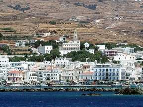 Tinos is a northern Cycladic island. It is located between Andros and Mykonos. Its main port and capital Tinos is dominated by the imposing rock of Exombourgo (640 m). Tinos is an island still relatively unknown to foreign tourists. Its ancient monuments are little known and its coasts are mainly composed of stones and pebbles although it still has some beaches of fine sand. Exposure to the northern winds, mainly the meltemi in summer, does not play in its favor either. This characteristic even made that in mythology, it was the abode of Aeolus, master and the steward of the wind. For the Orthodox Greeks,
Tinos is a place of religious pilgrimage, which attracts a large crowd on 25th of March (Annunciation Feast) and especially 15th of August (Assumption Day). It is also home to an important Catholic community. The harbor is a modern city and lively by the many cafes bordering the docks. The artery leading to the church of the Annunciation is paved with marble and lined with shops of religious objects.
Pyrgos is one of the most beautiful villages on the island and the largest after Chora. Marble sculpture has been a specialty for a long time. In the picturesque alleys one can admire the marble decorations around the windows, the lintels with decorative motifs, the fountains and the School of Fine Arts, from which are descended from the famous Greek sculptors. Kardiani is 16 km from Chora. It is located on the side of the mountain ‘Pateles’, surrounded by greenery and offers a view of the sea. Its streets are crossed by a stream that feeds marble fountains.
There are also three large churches: Agia Triada at the edge of the village, Kimisi in the center, and Kioura at the other end.
The village of Volax is situated on a plateau dotted with granite rocks which are the result of a volcanic eruption that took place thousands of years ago. They are of varied forms and give the landscape a special beauty. In the village there are basket weaving workshops, specialty of the place. In amphitheater facing the sea, the village of Fatalados has also remained very authentic.
Located north of Chora, it is an ancient village dating from 1400. Its inhabitants are mostly cattle breeders. You can visit the distilleries of Raki (strong alcohol) as well as the Folklore Museum.
The beaches:
– Porto: Less frequented and one of the most beautiful.
– Pacheia Ammos: The most beautiful area. Turquoise waters and golden sand.
– The small port of Panormos: In the north of the island, it is very picturesque and offers some uncrowded coves. – Kolimbithra Bay: It has two beautiful sandy beaches with clear waters.
– Agios Fokas: The largest and one of the most beautiful in Tinos. A few minutes’ walk from the town of Tinos (Chora).
– Stavros: A short distance from the west of the town of Tinos (Chora). Picturesque beach with the ruins of the ancient port.
– Agios Markos: Next to Stavros beach. Crystalline waters.
– Kionia: Just after Agios Markos. Several sandy beaches on this side.
– Agios sostis: A few km to the east of the town of Tinos, a series of popular sandy beaches with a view of Mykonos.
Do not miss: The villages of Pyrgos, Kardiani, Volax. The port of Panormos and the bay of Kolymbithra.