
Saronic islands
Aegina
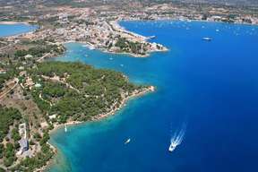
 Aegina is a Greek island of triangular form, in the center of the Saronic Gulf, 20 km south-west of Athens. Mount Oros dominates the island. The ruins of a temple of Zeus stand in the midst of other ancient sites. In the center stands a mountain of conical form, Mount St. Elias or Profitis Ilias in Greek (534 m).
Due to its important position in antiquity, there are still many ancient sites to see in Aegina, the most famous being the temple of Athena Aphaia, dating from the 6th century BC. The temple is close to the town of Agia Marina.
Aphaia is one of the three temples of the sacred triangle which also includes the Parthenon and the Sounion. It was for a long time a great rival of Athens, in antiquity as at the beginning of the 19th century. Aegina was one of the first maritime and commercial cities of ancient Greece. It had the first navy of Greece and was the first city to mint money. In 1828-1829 it was the first capital of Greece struggling for independence, and the first pieces of the young Greek state were issued. The island is also the main producer of pistachios from Greece.
According to mythology, Aegina was a beautiful princess whom Zeus fell in love with. To be alone with her, he took her in this uninhabited island, and they had a son, Easter, who became the first king.
In the town of Aegina you can visit the Archaeological Museum and the Monastery of Agios Nektarios. Paleochora is an abandoned Byzantine town which can also be visited. You will also be able to see the house where the publisher of Zorbas the Greek, Nikos Kazantzakis, lived for a few years or the mansion that hosted the first government of Greece, under the direction of Ioannis Kapodistrias.
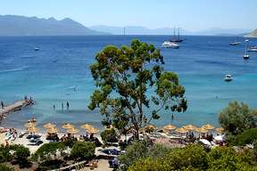
Agia Marina is the only place in Aegina that attracts mass tourism because of the proximity of the ancient temple and the developed tourist infrastructures. In Souvala, 10 km from the town of Aegina, there is the famous spa resort as well as beautiful beaches. The picturesque seaside village of Perdika with its small typical houses whose courtyards are connected to each other is built around the port. On the pedestrian area there are the famous tavernas of fresh fish and seafood. The waters are clear and the beaches are suitable for diving. In spring, the village is green and the hills full of flowers. Paléochora is the ancient capital of Aegina. It is here that the monastery of Agios Nektarios is located, and nearby, the ruins of a medieval castle.
The city has many buildings and houses in neoclassical style.
On the quay, you can visit the small white church of Agios Nikolaos and close to the church of Agios Dionysios, Aegina’s cathedral.
There are many pleasant sandy beaches with clear waters. The majority are equipped and quite frequented. The long beach of Agia Marina is probably the most popular.
The most pleasant are Marathonas, Souvala, Agios Vassilios, Kolona and Avra.
Alimos
 Alimos also known as Kalamaki is a deme located south of Athens in the periphery of Attica in Greece. It is a holiday resort for the urban population of Athens, known for its nightlife and beaches.
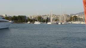
Alimos Marina is one of the biggest marinas in Greece with 1000 permanent places. This is the basis of many boats. The Marina is located in the south-west of Athens, 15 km from the city center, 8 km south of the port of Piraeus and 30 km from Athens airport.
Dokos
 Dokos is a small, quiet island in the Saronic Gulf, in the Aegean Sea, between Hydra and the Peloponnese. It belongs to the municipality of Hydra. Its surface area is 12.5 km and has about 50 permanent inhabitants. The island has few water reserves and the land is not very fertile.
Dokos is mainly populated by Orthodox monks and sheep breeders but also by a few fishermen and farmers. It is a rocky and mountainous island whose climax reaches 308 meters.
The lighthouse of Dokos, also called Lighthouse Nisos Dhokos, was rebuilt in 1923 and measures 9 meters high.
Numerous archaeological excavations have taken place on Dokos, which was an important port in the antiquity. The port was strategically positioned in the Byzantine era, where ships arriving in the Saronic Gulf were observed.
On the east side are the ruins of a large Byzantine citadel that offers an impressive view of the surrounding area.
The island is known to nature lovers, hikers and campers for its tranquility. Dokos has a camping place, north of the island and two chapels.
Among the attractions of the island is the convent of Santa Eupraxia, opened to pilgrims of Orthodox faith.
The beaches of Dokos are small, clean and the waters are clear.
Epidaure
 The Deme of Epidaurus is an administrative district (corresponding to a municipality or a district) of the Periphery of the Peloponnese, in the regional district of Argolida. It takes its name from an ancient Greek city.
The headquarters is the village of Lygourio, the ‘historic capital’ being the village of Ancient Epidaurus. Ancient Epidaurus is a small modern town located on the site of the ancient Greek city, located on the coast of Argolis.
The city is full of monuments dating back to a very distant period, such as the Temple of Asclepios, which was founded long before the birth of Jesus Christ. The sanctuary of Asclepios is located inland, in the territory of the municipal district of Asklipio, about ten kilometers west of the coast, at the ancient place called ‘Hiero’.
The village of Piada was renamed Néa Epidavros (New-Epidaurus) after the independence of Greece in the nineteenth century. In 1822 it housed the National Assembly of Epidaurus, which was the first meeting of what is now the Greek Parliament. Nearby are the ruins of a Mycenaean acropolis.
The village of Ano Epidavros is another locality.
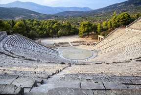
Epidaurus is famous for its theater dating from the 4th century BC. AD, one of the best preserved and probably the most beautiful theater of all ancient Greece. The theater is renowned for its perfect acoustics.
Originally, this place in the midst of the hills of Argolis was the sanctuary of Aesculapius, the divinity of Medicine. The sick went there to be cured by Aesculapius, who could either recover during sleep, or manifest themselves in dreams which the priests then translated into treatment.
These treatments could be accompanied by entertainments, baths, and physical exercises. Every four years, competitions of music and poetry took place in Epidaurus.
The theater comprises 55 rows of bleachers; it could accommodate about 14,000 spectators.
On the site one can also discover the sanctuary of Esculape where the patients and the vestiges of the stadium went. The museum gathers some objects, sculptures and pediments.
Fokianos
 Fokianos is a small fishing village in Arcadia, in the Peloponnese, 33 km south and 20.5 nautical miles from Leonidio.
It is a quiet, green and mountainous village typical of the Peloponnese, which is best known for its beautiful bay, which has a quiet beach with turquoise waters and white stones where the yachts stop between two routes to relax and refresh. Two small taverns not far from the beach serve fresh dishes and sell various products for travelers.
Hydra
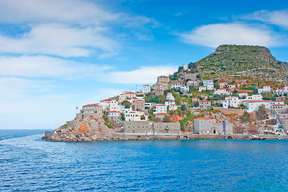
 Hydra is a Greek island in the Saronic Gulf, south of Athens, in the Aegean Sea, opposite the Argolis peninsula. It is a picturesque island with wild coastlines and mountainous terrain. Its surface area is 50 km and it has 2000 permanent inhabitants. Mount Eros or Vigla, peaks at 593 meters.
Apart from three coves, the coast is rocky and inhospitable to ships, which once favored the defense of the island. The interior, mountainous, is rocky and covered with scrubland, more conducive to extensive breeding than to crops. The gray hills often end in coastal cliffs.
Hydra has become a fashionable seaside resort. It is considered the pearl of the Saronic islands and in season it is prized by the Athenian bourgeoisie. Forbidden to any motor vehicle, it is on foot, by donkey, and in water-taxi that one moves on the island. Hydra is more expensive than other islands.
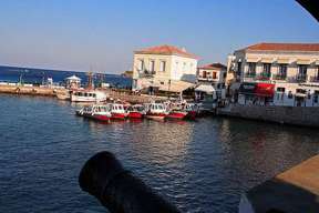
The town of Hydra is the main port and the only city on the island. The port is full of charm. Its neoclassical houses with red tiles and numerous alleys have a lot of character. In time, it was protected, at the entrance of the port, by cannons that can still be seen.
The historic Tombazi mansion houses an annex of the Athens School of Fine Arts. On the quay, the monastery of Kimissis Theotokou houses the main church of the island. Fifteen minutes’ walk to the west is Kaminia, a fishing hamlet. Mandraki, about 30 minutes walk from Hydra to the east. It is the port where the shipyards were in the 18th and 19th centuries.
The beaches in Hydra are few in number but you can still find some nice beaches in Molos, Agios Nikolaos, Palamida and Kaminia.
Kyparissi
 Kyparissi is a village in Zarakas, Laconia, in the Peloponnese region, 300 km south-west of Athens. It is considered by some as one of the most beautiful picturesque villages in Greece and yet is one of the least visited destinations in Greece.
It is also an ideal site for climbing with at least 15 different climbing routes passing through vertical rocks of limestone, adorned with stalagmites and caves.
Kyparissi is an authentic village. Apart from climbing, there is not much to do but what makes this village unique is the setting (the view from the rocks and the sea) and the quiet.
The beaches of the village impress visitors with their beauty and purity.
Megali Ammos is located in Paralia. Another beautiful beach next to the port is Mikri Ammos.
Leonidion
 Leonidio is a village in Arcadia, 200km south of Athens, on the eastern coast of the Peloponnese. It has 6000 inhabitants. This small seaside village is overlooked by beautiful limestone cliffs of 250 meters high which are suitable for climbing. Climbers from all over Europe find themselves there.
The traditional architecture of the village is interesting with its square houses and towers. The inhabitants are of Tsaconian origin, a very ancient people with a particular dialect. Plaka is the small picturesque harbor of Leonidio, with fishing boats, a few yachts and sailboats. The beautiful beach of Plaka begins at the port and is shaped like a crescent. To the north of the harbor is Lako Beach, which faces the island of Spetses.
The monastery of Panagias Elonis is perched on the middle of a cliff. It is a quiet and relaxing place with a beautiful view. The Monastery of St. Nicholas Sintza is also impressive and worth a visit.
The Arcadian mountain is characterized by impressive mountain peaks, abyss and abrupt gorges, rivers with torrential waters and luxurious vegetation, ancient cities, Byzantine churches, castles of the Franks and villages with well-preserved traditional architecture.
Monemvasia
 Monemvasia or Malvoisie is a fortified city of Greece located south of the Peloponnese, on the east coast of the regional district of Laconia. It is a rocky peninsula similar to Gibraltar. It is connected to the mainland by a short causeway. The island is about 300 meters wide and one kilometer long and rises on a plateau about a hundred meters above sea level.
The locality is composed of two districts. The Kastro is the historic town on the peninsula and the modern Gefyra district on the mainland, which is home to the port and most of the tourist infrastructure.
Monemvasia was built during the 6th century by the inhabitants of ancient Laconia seeking refuge from the Slav invaders who dominated much of Greece between 500 and 700 AD. This enormous rock was not visible from the mainland, so the inhabitants avoided enemy attacks. At the time, the only way to reach Monemvasia was by boat. It was only later that the paved road was built to connect the entrance of the castle to the mainland.
The rocky island had been separated from the mainland by an earthquake in 375 AD. Over the centuries that followed, Monemvasia changed hands several times, in both directions, between the Venetians and the Turks, until the small town was liberated in the Greek War of Independence at the beginning of the 19th century.
The castle of the city of Monemvasia is one of the most impressive places in Greece. The whole city is made up of castles, old houses, cobbled streets, ancient squares and churches.
From the main square of Monemvasia, dominated by an old cannon, you can observe the church of Elkomenos Christos and a 16th century mosque that houses the archaeological collection of the city.
Nafplio
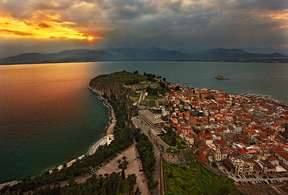 Nafplio is a Greek city of Peloponnese. Capital of Argolida, seat of a bishopric, located on the seafront, it is a historical and tourist city which has 14,203 inhabitants. Its surface area is 387.8 km.
The town is located on the northern slopes of the Itch-Kalé peninsula (85 m) or Acronauplia.
It is a city with neoclassical buildings, old quarters, pedestrian streets and large squares preserving the legends of its past.
The city has been occupied successively by the ‘Franks’, the Venetians and the Turks, who left their mark. The city is dominated by two fortresses: Acronauplia and Palamidi. Acronauplia is the acropolis of Nafplion. It was built by the Venetians and later passed under Byzantine control, then Turkish. It is built on three levels, each constituting a different fort with walls built at different historical periods. Palamidi, from the top of its 999 steps offers a unique panorama of the city and the sea. The fortress was built between 1711 and 1714.
Nafplio was the second capital of the free Greek state (1828-1834), after Aegina. The entrance to the port, facing the city, is guarded by the fortress Bourtzi, Venetian style. You will discover its hexagonal architecture. It is one of the major attractions of Nafplio. Today it is a place of temporary exhibitions and music festivals after being for many years the residence of executioners of Nafplio, then a luxury hotel. Its objective was mainly to protect the port, doubling the protection assured from above on the Acronauplia.
You will not miss Syntagma Square which is the place of the Constitution, the former Venetian Foro, main square of the city.
There are several museums in Nafplio: the Archaeological Museum, the Museum of the Army, the Ethnographic Museum and the Kombolo Museum.
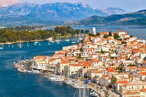
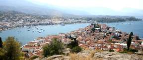
Poros
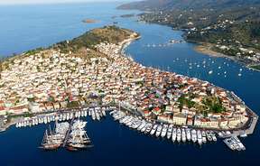 Poros is a Greek island in the Saronic Gulf. It is very close to the Argolis. With a surface area of 33 km, it has 3500 inhabitants. Poros is mostly separated from the Peloponnese by a narrow channel of 250 m to 400 m wide.
Poros is actually made up of two islands, Sphaeria (or Sféria), where the city and the port are, and Calauria (or Kalavria). These two islands are now connected by a bridge which crosses the narrow isthmus. The island of Sphaeria has a volcanic origin. Both islands are mountainous and verdant and the hills are covered with pines.
Upon arrival, you can see a hill overlooking the port, built on the peninsula of Sphaeria, covered with white and picturesque houses. Inside the island, there are beautiful alleys, where neoclassical buildings and small white houses with colored shutters mix. To Mikro and Megalo Neorio you will find marinas for yachts and boats.
The ruins of the temple of Poseidon dating from the 6th century BC and the Zoodochos Pigis monastery (Life giving source) are just about the only two tourist sites to be seen on the island.
The beaches are not numerous on the island but Poros offers both sandy beaches and pebble beaches. Most of them are on the south coast of Kalavria and many take one of the many small boats to get to the Galatas beach on the mainland. In general, the beaches of Poros are very quiet, as they are located in rather sheltered bays. Between Megalo and Mikro Neorio there is a beautiful beach, and another on the side of Askeli.
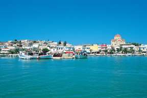
Porte Heli
 Porto Heli sometimes spelled Porto Cheli, is a Greek seaside resort in the Peloponnese on the Argolic Gulf. Porto Heli has just over 2,100 permanent residents. Porto Heli is located 85 kilometers south-west of Nafplio and about 230 kilometers from Athens airport.
Porto Heli has a marina and tourist facilities and is close to the tourist sites of Epidaurus and the Argo-Saronic Islands. This port is a frequent mooring for boats of all kinds.
Near the present city of Porto Heli is the site of the ancient city of Halieis. You will see the traces of the foundations of an acropolis (dating from 700 BC). The ancient city is now immersed.
Spetses
 Spetses is a Greek island of the argolic gulf, located 2 nautical miles from the mainland and 52 nautical miles from Piraeus. Spetses is often considered part of the Saronic islands, as are the neighboring islands of Dokos and Hydra. Spetses has a population of just over 4,000 and has an area of 27.1 km.
The capital is Spetses, whose port of Dapia is dominated by the Platia, a beautiful fortified place full of history. There are many old buildings and beautiful shipowners’ houses. The streets paved with black and white pebbles evoke marine motifs. The house of Bouboulina is a private museum which is now opened to visitors. You can also visit the manor of Sotirios Anargyrios, the benefactor of the island at the beginning of the 20th century.
The monastery of Agios Nikolaos (Saint Nicholas) is located just outside the town of Spetses, and is opened to visitors. The patron saint of this monastery is also the patron saint of the sailors, and it is here that the leaders of Spetses took the oath of freedom when the War of Independence was about to break out in 1821.
In Spetses you will find both pebble beaches and sandy beaches. The most popular are Agia Paraskevi, Agioi Anargyroi and Agia Marina.
Everyone agrees that Zogeria is the best beach on the island and offers an ideal setting for relaxing.
The beach of Vrellos is just as pretty. It is a sandy and pebble beach, surrounded by pine trees.
Kaiki Beach also known as College Beach because of its proximity to the Anargyrios College is a fine sandy beach, popular for its water sports.
Yerakas
 Yerakas or Gerakas is a primitive village on the Saronic Gulf on the eastern coast of Laconia and 22 km from Monemvasia. It is a village nestled between the mountains. Yerakas is at the bottom of a bay that forms a fjord. It is the only fjord in Greece. Yerakas is not affected by mass tourism.
Gerakas or ‘Ierax’ as it was called in Byzantine times is a refuge for birds but also for visitors in summer. The large safe bay is not visible from the sea and has always aroused the interest of sailors, pirates and conquerors. It was the naval station of the Byzantines to fight the Saracens and an anchorage for the merchants of Hydra and Spetses, but also a shelter for those who wanted to avoid storms and violent waves.
Today, Gerakas consists of three hamlets: the port, Gerakas and Ag. Ioannis.
The traditional whitewashed houses with their blue windows and a beautiful natural environment make up the village of Gerakas, perched on the hill.
Following the road up, you will arrive at Ag. Ioannis (Saint John) where you can enjoy the calm, fresh wind, the green landscape and the traditional houses.
The beautiful picturesque port that recalls the islands of the Aegean Sea rather than a village of Laconia is today a mooring place for yachts and boats because it is protected from the winds. You will also find some rooms to rent, restaurants, and especially taverns of fresh fish, sins in the morning.