
Dodecanese
Arkoi-Marathi
 Arki or Arkoi is a small island in the Dodecanese archipelago in Greece. It belongs to the municipality of Patmos. With a population of 44 inhabitants, the island does not have a real city, but most of the inhabitants live close to the main port. The population works mainly in the fields of fishing and goat breeding.
The land on the island is characterized by dry, rocky soil. The vegetation is formed of garrigue, with olive trees and some shrubs. The fauna consists mainly of livestock. It is possible to observe herons on the island. Marine life, unlike other Greek islands, is rather well preserved and includes several species of groupers or nudibranchs.
You can walk on the island and discover many interesting places, such as the Italian fortress, the caves, a shelter for the local occupants or many paths that lead to mysterious places on the island. Like every Greek island, Arkoi has its small churches. The most beautiful is probably the church of Panagia which enjoys a splendid view on the surrounding islands. Some other churches are: Agioi Anargiri, Metamorphosi, Agios Lefterios.
On the island, with the exception of the peace and tranquility which are the major assets, there are some beautiful beaches. Tiganakia is the most beautiful beach and is famous for its transparent blue waters. The beach is surrounded by rocks that protect from strong winds. Other beaches, just as beautiful as Limnari, Padelia and Kapsaliasmenos are not far.
The nearest inhabited island is Marathi, but the nearest islands with a large population are Lipsi and Patmos.
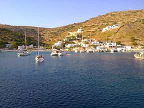
Marathi is a tiny rocky island of 355 acres east of the island of Patmos and west of the island of Arkoi with a total coastline of about 4 km. It is part of the Dodecanese Archipelago.
Marathi is a refuge for birds but also for many people who want to get away from the lights of civilization and the noise of big cities. There are no roads, shops or cars that could disrupt the tranquility of nature, apart from the goat-bells that roam freely on the island. It is an ideal destination for those who like to enjoy the tranquility of nature and isolated places. On the island there is a lovely beach, an old blue dome church, a restaurant serving fresh produce directly from nature and 10 rooms for rent.
Agathonisi
 Agathonisi is a small island located at the northern end of the Dodecanese prefecture in Greece. It is surrounded by numerous small islands and houses two villages: Megalo Chorio (Large Village) where most of the inhabitants live and Mikro Chorio (Small Village). The port of the island, St. George (Agios Georgios), depends on Megalo Chorio. There are a few hotels.
The highest point on the island is 209 meters above sea level. This summit is located near Mikro Chorio. The island has an area of 13.5 km2 and has 160 inhabitants. The community of Agathonisi, which includes the uninhabited islets of Glaros, Kounéli, Nera and Psathonísio, has a combined area of 14.5 km2.
It is a quiet, peaceful place, away from mass tourism. There you will find 2 grocery stores, a small protected harbor on the other side of the island in Katholiko, where Agathonisi fishermen and ‘domes’ are lost in the scrub and garrigue. These are Byzantine buildings of the eleventh century where food was probably stored.
You will also find some small isolated coves with crystal clear waters.
Astypalaia
 Astypalea or Astipalea is one of the main islands of the Dodecanese. Its surface area is 114 km and it has 1200 inhabitants. The coasts of the island are rocky, with many bays and beaches and the island is surrounded by islets. Situated exactly where the Dodecanese meets the Cyclades, the island of Astypalaia has a century-old history, whitewashed villages and sunny beaches.
In Greek mythology, Astypaleus was carried off by Poseidon, in the form of a winged leopard with a fish’s tail, at the same time as his sister Europe, abducted by Zeus. She would then have been finally petrified to form the island. The island takes its name from Astypalaia, the daughter of Phoenix and Perimede.
In the past, the island was also called Ichthyoessa because of its abundant fishing areas. It was inhabited for the first time in prehistory. As is the case with the other islands of the Dodecanese, Astypalaia remained under Turkish rule until 1912. It was later conquered by the Italians, the British and the Germans until it was finally reunited with Greece in March 1948.
Since antiquity, its port has always been safe thanks to its ‘serrated’ aspect. The first houses, the remains of which are found in Messa-Vathi (tower), appeared in Cycladic times. There are also vestiges of the Mycenaean period (tombs built in dome) in the area of Arménochori-Sigairo.
Astypalaia, the westernmost island of the group, is naturally separated into Mesa Nisi (the inner island and the western part) and Exo Nisi (the outer island and eastern part) by an isthmus of 100 m. It has the very characteristic shape of the island in butterfly. Today, Astipalaia has 4 villages: Chora and Livadi in the south-west of the island, Analipsi in the center and Vathi in the northeast.
Chora is the capital and port of the island. It is one of the most picturesque towns in the Aegean Sea. It is perched on a rock that overlooks the sea forming two bays. At the top of the hill you will see the Venetian citadel of Chora which overlooks the city.
All around the castle are the two-storey houses with their whitewashed walls, blue doors and windows and small balconies. The stairs are made of stone or wood and two small churches (St Georges and Evangelismou) are part of the decor. You will also see windmills, characteristic of the capital.
The church of Panagia Portaitissa just at the foot of the castle is among the most beautiful on the island. It was built in 1764. The icon of the Virgin Mary is a faithful reproduction of the icon of Panagia Portaitissa of the Iberian convent of Mount Athos (northeast of Greece).
Livadia is a seaside village 2 km from Chora with few residents, built on a fertile valley (vineyards, mandarin trees, vegetable gardens …) creating a relaxing setting, next to a beautiful beach.
The village of Analipsi is 9.5 km from Chora. It is a resort that attracts most of the island’s tourism. Maltezana takes its name from the Maltese pirates who made their hiding place on the island. It was there that the French admiral Bigot set fire to his ship in 1827, in order not to be captured by the pirates.
It lies on a small fertile plain on the north side of the island. There are many sights to see on the island, including the Analipsi chapel, at the end of the village and the Agia Varvara chapel, built on the site of the ancient temple of Artemis. There are some beautiful mosaics from the 3rd century in the chapel.
The village also has a monastery called Panagia Poulariani and a beautiful beach. There are also beaches around the village, in Vryssi and Shinonta. Makrigialos is a village adjacent to the village of Analipsi. Excavations in the area have brought out a Minoan villa. A villa from the Roman period was also found in the area.
From Maltezana creek, take a small sightseeing boat and visit the islands of Diaporia, Ligno, Chondro, Kounoupoi and Koutsomyri as well as Agia Kyriaki Island and its beautiful beach. Farther north-east of Astypalaia, visit Fokionisia. Then Panormos and Katsagreli to the northwest and Pontikousa and Ofidousa to the east. And finally the islands Syrna, Katsikoulia, Tria Nisia, Meso, Stefania and Zafora in the Southeast.
Vathy is a fishing village located north-east of Astypalea, 21 km from Chora. It includes two districts: Exo [outside] Vathy with a small quay to moor boats; And Mesa [inside] Vathy, next to cultivated land, vegetation and vineyards. In Vathy there are beautiful and calm beaches with crystal clear waters.
Near Vathi, there are two old caves. The first known as the Dragon Cave with magnificent deposits of stalactites and stalagmites and the second is the Black Cave.
Halki
 Chalki or Halki is a Greek island located in the south of the Aegean Sea 6 km west of Rhodes. It has 280 inhabitants and extends over 37.04 km. Administratively it forms with a few islets a deme of the Dodecanese. A very mountainous island without tourism, it offers amateurs a primitive island life. You will find a dozen restaurants and bars and a few rooms for rent. The interior of the island is a maze of passages sometimes narrow, sometimes steep, between beautiful restored houses and also many ruins of the 1944 bombings.
The capital and main port of Nimborio Island, whose neoclassical architecture recalls that of Symi, is built in an amphitheater around the port on the south-east coast. The ancient capital Chora, now abandoned, was located in the interior of the island, where the inhabitants had taken refuge to escape the pirates. At the time of its prosperity, the city had about 4000 inhabitants. There are ruins of a medieval castle built on the site of the ancient acropolis, and the church of Agios Nikolaos with its mural paintings. Among the curiosities of the island are the monasteries of Taxiarche Archangel Michael, Ai-Yiannis, Agia Triada, and Stavros.
There is no supply station for recreational craft. You can visit by boat the neighboring islet of Alimia in the north-east of Chalki, which has beautiful sandy beaches. In Halki, enjoy the beautiful beach of Pandamos and some nice beaches in Alimia.
Halki is perfect for those looking for calm and rest.
Kalymnos
 Kalymnos or Calymnos is a mountainous island in the Dodecanese, in the Aegean Sea. It is 12 km north of Kos Island, 2 km south of Leros and near Turkey. It is an island spared from mass tourism with locals with a sense of hospitality. Kalymnos is an island of 110,581 km2, the fourth largest in the Dodecanese by its size, similar in geographical form to Great Britain (or comparable to that of a scorpion).
It is a limestone island, but it has in the center a valley composed of volcanic tuff, vestige of an ancient volcanic past. The highest point is Panagia Kyrapaili with its chapel at 608 meters above sea level.
The island of Kalymnos owes its fame to its fishermen and sponges, known throughout the world for 500 years. Today there is no more sponge in Greece and the island lives mainly from tourism. Some villages remained authentic, like Vathy.
According to mythology, Kalymnos would have got his name from Titan Kalydnos, who was the son of Gaia (‘Earth’) and Uranus (‘Heaven’). It appears that one can see his legs raising his head: two plains on either side of a mountain.
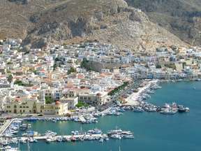
Pothia is the capital and port of Kalymnos. A densely populated area built in the early 1850s. The neoclassical houses are brightly colored and built in amphitheatres and on the water’s edge one can see the imposing Metropolitan Church of the Christ Our Savior whose interior is decorated with frescoes and old Icons. In the archaeological museum and Kalymnos located in the city, there are a large number of sculptures, tools, pottery, weapons and marble pieces date from prehistory and the Classical period. You will also find the Nautical Museum of Kalymnos, near the port of Pothia, where ancient sponge workshops are on display, as well as a collection of folk objects.
In Chora or Chorio, the ancient capital of the island for several centuries, you can see the Paleochora Castle built in the 11th century by the Byzantines and then occupied by the knights of Saint John from the 14th century. This fortress could accommodate a thousand inhabitants at the time of piracy. Today Chora or Chorio is an extension of Pothia. Chora was built on a valley, far from the sea, due to pirate attacks. It is a place that preserves its traditions.
The west coast of the island is dotted with seaside resorts. Those of Myrties and Massouri offer the most beautiful beaches of the island. The road stops at the village of Emborios, in the north, whose large quiet beaches contribute to the relaxed atmosphere.
Telendos is a small rocky island separated by an inlet of 800 meters west of Kalymnos. It has 90 inhabitants and is accessible by boat. There is a beautiful beach and the quiet of a picturesque little island. There are three other islets, Pserimos, Plati Pserimou and Kalolimnos.
Karpathos
 Karpathos is a Greek island of 324 km, located between Crete and Rhodes. It is the second largest island in the Dodecanese. Its beaches, which are difficult to reach, are among the most beautiful in the Dodecanese. It is a quiet island of 7000 inhabitants which remains spared from mass tourism.
Karpathos forms a small archipelago with two nearby islands: Saria separated to the north by a narrow tongue of land of 100 m and attached to the community of Olympos and Kassos to the southwest located about 7 km. Half the island is rough and inaccessible and the other is very green. The architecture is varied with authentic small houses on the one hand, and modern buildings on the other. A part of the local population, mainly on the side of the village of Olympos, dresses in brightly colored traditional clothing and the local folk tradition remains.
The traditional village of Olympos is a village built in amphitheater, at 250m altitude, facing the sea. It is a village keeping its medieval architecture typical of the Greek islands of the south-east. The village is located in the extreme north of the island and until recently it was not accessible by car.
The main town of Karpathos (or Pigadia), located to the south-east also serves as the main port to the island. Its ancient name is Potideo or Posidio. It is built on the edge of a four kilometer sandy beach. The houses are recent and modern. The center is located between Place Polytechniou, the quay and Dimokratias Street.
8 km south of Pigadia is the bay of Ammopi and a succession of beautiful coves with crystal clear waters.
Apella, elected a few years ago as one of the most beautiful beaches of the Mediterranean, is the most famous of Karpathos. Located just 16 kilometers north of Pigadia, it combines crystal clear waters with fine pebbles. The pines are mixed in the rocks, all around the beach.
Other known beaches in Karpathos for their clear waters are: Kyra Panagia, Achata, Lefkos, Finiki, Arkassa, Damatria, Diakoftis, Afoti, Psoraris, Michaliou Kipos, Varias and Vrontis.
Kassos
 Kassos is a Greek island of the Dodecanese. It has about 1,000 inhabitants and its area is 69.46 km. It is the most southerly island of the Dodecanese. Kassos is first mentioned in the Iliad of Homer as an island whose inhabitants fought in the Trojan War. The island was also named Amphe, Achne and Astravi.
Small, calm and welcoming, Kassos remains away from tourist flows. It is the island of origin of some ship owners, who return for the summer and also a former pirates hideout.
The capital and the port of the island is Fri. Fri is very picturesque with its stone houses. There are many churches in Agia Marina. At 3 km to the South-East, the ancient capital of Poli Island preserves remains of a Venetian citadel. There is also the beautiful church of Agia Triada and interesting churches in Panagia (1 km east of Fri).
In Ellinokamara you can visit caves where archaeologists have found traces of Neolithic settlement. Sellai is a cave of stalactites.
In Chadies, 12 km to the south-west, there is the monastery of Agios Georgios and the monastery of Agios Mamantas in Apokrani. The most beautiful region is that of the Arvanitochori village, built in the only valley of the island with a green landscape. The rugged coastline of Kassos is unsuitable for sea bathing but rich in fish. The neighboring and uninhabited islet of Armathea is accessible by boat.
There are few beaches in Kassos but Helathros and Ammouda are considered the most beautiful.
Kastellorizo
 Kastellorizo or Megisti is an island of 9 km2 of area with about 300 inhabitants and is bathed by the eastern Mediterranean Sea. The small island of Kastellorizo enjoys a very particular geographical position: it is off-center from the rest of the archipelago. It is located in front of the Turkish city of Kaş, less than seven kilometers away, and about 130 kilometers east of Rhodes.
More known as Kastellorizo, the bay surrounded by neoclassical and colorful houses is guarded by the fortress of the knights of the Order of Saint John, built on red rocks. This is why this fortress was called Kastel Rosso by the Italians, then Kastellorizo by the Greeks.
The only village on the island is Megisti. There you can visit an archaeological and folklore museum, as well as some churches. The Church of Agios Konstantinos and Eleni was built partly with materials from the ancient temple of Apollo in 1835, while the church of Agios Nikolaos was built over the same temple.
Kastelorizo, which lives mainly from tourism, is totally dependent on its water and food supply. It is mainly supplied by Rhodes and also by Kaş for fruit and vegetables.
The coasts of the island are rocky and there is no beach. Nevertheless the waters are crystalline. On the northern coast of the island you can visit by boat the beautiful cave of Parastra or Fokiali, a cave of stalagmites and stalactites. In the natural basins filled with rainwater, one can admire the blue reflections lit by the rays of the sun. The visit is only by boat.
Kos
 Kos or Cos is a Greek island of the Dodecanese, in the Aegean Sea, 4 km from the Turkish coast and the city of Halicarnassus (Bodrum). Its surface area is 287.2 km and it has about 31 000 inhabitants. Its climax reaches 875 meters. Kos is the third largest Dodecanese Island after Rhodes and Karpathos. It is a green and fertile island.
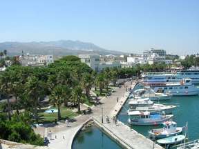
Kos is the capital and port of the island. The central square is called Elefterias. There is an archaeological museum, the maritime fortress of Neratzia dating from the 15th century where the Knights Hospitallers of St. John held power, the Hippocratic plane tree planted 2400 years ago where it would have taught and read its oath, The Gazi Hassan Pasha mosque dating back to 1786. The biggest curiosity of the city is the ancient Asklipi hospital, which was once cured with holy water. Today, it is only the fragments of the foundation and some columns that have remained of the hospital.
Kos has a few small villages that are worth a visit. Palio Pylio is an abandoned medieval village where you can find a lot of small churches and a castle of the Hospitallers on a high rocky summit.
In Asfendiou there are ancient churches and a castle. Kefalos was the capital of the island in antiquity, it was called Astypalea. Excavations of the city continue today.
Zia, near the village of Asfendiou, is a small village built as an amphitheater with many small churches and shops. It is a traditional village surrounded by woods and fruit trees. A road accessible by foot will lead you to the mountain, at the highest point of the island. Zia is also famous for its sunset and its panorama.
In Kardamena you can see a Byzantine church dedicated to Agios Theodotas, and in Antimachia, a castle. Antimachia is a picturesque village located on a low and arid plateau. Kos airport is not far away.
The most important fortification of the Knights of St. John on Kos is Neratzia in the capital but they also owned castles in Pylio, Andimachia and Kefalos. The purpose of these fortresses was to ensure the safety of Christian pilgrims and travelers on their way to the Holy Land against Ottoman attacks and attacks by pirates.
Empros, 12 km southeast of the city of Kos, is mainly known for its thermal spring, Therma Beach, which is one of the island’s attractions. It is located at the bottom of a cliff, on a square of pebbles and black sand.
Kos is the only island in the Dodecanese to have three different sources of thermal water – very hot, hot and cold. You will find them in Agios Fokas, Pisso Thermes, Kokkinonero and Volkanous.
The most popular beach in Kos is the beach of Paradise in Kefalos, a long sandy beach where you can practice water sports. The other popular beaches are those of Mastihari, Lambi and also the beach of Kardamena. The quieter beaches lie on the west side of the island.
Leros
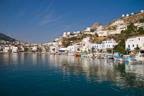 Leros is an island in the Dodecanese archipelago in the south-east of the Aegean. Its surface area is 53 km2 and it has more than 8000 permanent inhabitants. It is 317 km from Athens and 35 km from the Turkish coast. Since the beginning of its history and because of its strategic position, Leros was the subject of discord for many conquerors until it was integrated into the Greek state in 1948.
Leros is a small mountainous and green island, with high hills and numerous small coves and villages. Leros has retained its authentic character because it has been spared from mass tourism. Most of the buildings are Italian-style, but you will also find typical white houses with blue doors and shutters.
Platanos with the villages of Agia Marina and Panteli constitute the capital of Leros.
Its main ports are Lakkí and Agia Marina. Leros with a very large natural harbor, many sailing yachts and yachts come to anchor in summer, giving the island a cosmopolitan and international character.
The capital, Platanos is dominated by a Byzantine fortress dating from the 11th century and was once a stronghold for the knights of Saint John, as well as the Church of the Virgin Mary (Panagia tou Kastrou) which is the symbol of the island. According to the legend, the icon of the Virgin is miraculous, it appeared from the sea and was installed between two candles in the powder magazine of the castle despite the attempts of the aga to remove it. There is also a museum of discoveries from different eras and you can visit the ancient Cathedral of Agia Paraskevi in Platanos.
The other villages are Pandeli, Xerokambos, Partheni, Alinda, Kamara, Gourna.
A sailing school is located in Lakki and a scuba diving school in Xerokampos.
Next to Xerokampos you will see the ruins of an ancient citadel: the Paleokastro.
Towards Alinda, which is the main seaside resort of the island, you can visit the church of Agios Isidoros, in the Kokkalis region, erected in the middle of the sea and connected by a narrow path to the land. It is also the favorite church of couples for a romantic wedding. It was built on the ruins of an ancient temple or the castle of the Belenis Tower which is opened to the public and where are exhibited discoveries made on the island.
In Partheni, just before the airport you will find the ruins of a temple dedicated to Artemis and Xerokampos, the church of Panagia Kavouradena (Our Lady of the Crabs). Legend has it that a fisherman found a picture of the Virgin and was cured in a moment of a crab bite in his hand. He then dreamed that a woman dressed in black asked her to take the icon back to her place, and the church was then erected on this site. The icon of Panagia tis Kavouradainas which represents the Virgin between the legs of a crab is preserved there.
In a tunnel near Merikia, a few hundred meters to the west of the port of Lakki, is the open-air museum of War, devoted to weapons, uniforms and other objects of the Second World War.
There are many beaches in Leros. The touristiest is Alinda and Agia Kioura is very popular for its blue waters. Beyond that, you will find the beaches of Panagies and Dyo Lisgaria. To the west of the island are the beaches of Gourna, one of the few sandy beaches of the island and, in the same area, you will see Kokali and Drymonas.
On the Lakki side, you can find the beaches of Koulouki and Merikia, and to the south of the island the Xerokampos beach, partly sandy and ideal for diving. To the north of the island is the organized beach of Vromolithos, and the pretty beach of Blefouti about 1 km beyond the airport of Partheni. Finally, the beach of Pandeli which is a pebble beach with clear waters, located about 2 kilometers from Agia Marina. It is one of the most beautiful beaches in Leros.
Lipsi
 Lipsi, Leipsoi or Lipso is a Greek island of the Dodecanese to the south of Samos and north of Leros. It is a green and authentic island where cars are rare. According to legend, Ulysses would have met the beautiful Calypso.
Lipsi is the only island to be inhabited in a mini-archipelago consisting of a main island of about 16 km2 surrounded by 25 islets of a few tens of square meters. The highest point has an altitude of 277 meters. Today a protected nature reserve project is being set up under the aegis of Europe and partly financed by donors in Vroulia Bay in the north.
In the capital, Lipsi, you will find several churches with blue domes, the most dominant being the church of Agios Ioannis. There is also a small museum with archaeological finds and icons.
Kimissi Mountain was a hiding place for the hermits. You will find a church dating from the 16th century dedicated to the Virgin Mary.
Most of the isolated and protected bays like Moschato Bay in the north of this island have been used by fish farming.
One of the most popular sandy beaches is Platis Gialos, located in a sheltered bay with clear water.
Two other beaches frequented by tourists are Katsadia, a sandy beach to the south and Koklakoura which is a large bay with a pebble beach.
Nissiros
 Nissiros or Nisyros is a Greek island of the Dodecanese, located in the south of the Aegean Sea between Kos, Tilos and Rhodes. Its area is 41 km2. The island has many natural beauties and a rich cultural heritage that the inhabitants keep alive. The most striking feature of the island is its active volcano. It is the youngest volcano in the Aegean Sea whose last eruption, geothermal, dates from 1887.
Nisyros was born after a series of eruptions of the unique volcano in Greece. Access to its craters is easy and thousands of tourists and scientists visit it each year. The volcano and the tranquility that reign in the picturesque villages are two of the main assets of the island.
The island is surrounded by four islets also of volcanic origin: Gyali, Pergoussa, Paheia, and Strogyli Kasou. Almost in the center of Nissiros, on the plateau at Lakki, the crater of the extinct volcano, Polybotes (diameter 260 m and depth 30 m) opens. Steps lead to the center, with soft ground. The smell of sulfur is very marked.
According to mythology, Nissyros was originally united with Kos. When the battle between the Gods and the Titans broke out, Poseidon chased the giant Polyvotis and finally caught up with him in Kos, where he impaled him with his trident. The shock was so strong, that the island was divided into two parts, thus creating the island of Nissiros. One can still hear the giant sighing in the volcano. According to another myth, the first king of the island was Thessalus, son of Heracles.
The capital and port of Nissiros is Mandraki, located to the northwest at the foot of a steep hill. Its white and brightly colored houses form an impressive contrast with the dark color of the volcanic soil on which they are built. The castle overlooks the city and overlooks the sea and a folklore museum with various exhibits restoring the history of the island.
In addition to visiting the volcano, you can also visit the picturesque villages of the island: Mandraki, Pali, Emporios and Nikia. These 4 villages are built according to the architectural style of the island. In Mandraki, you will meet the monastery of Panagia Spiliani with its iconostasis which is inside the Castle of the Knights of Saint John.
To the south of the island, the village of Nikia perches on the crest of a hill, 400 m above sea level. Its white houses with colored doors and windows and tiled roofs shape the green countryside.
The monastery of Panagia Kyra, the chapels of Evangelistria and Stavros, the acropolis of the old town of Emporios, or Palaiokastro, the Knights’ Castle, the History and Folk Museum, the thermal springs of Loutra, 2 km east of Mandraki and Pali, Avlaki and Shirous are also worth a visit.
Nissiros has many beautiful coasts suitable for swimming and fishing. In Mandraki there is a beautiful sandy beach and a little further east in Cholchaki, a large beach with black pebbles of volcanic origin. This is probably the most beautiful and typical of Nissiros.
In Agia Irini and Paloi, there are some pretty calm beaches. The beaches of Aspri Ammos and Ammos Pachia are white sandy beaches. At Avlaki, the waters are crystalline.
Patmos
 Patmos is a Greek island of 45 km, part of the Dodecanese archipelago, in the Aegean Sea. It lies between the islands of Leros and Ikaria. It has 3000 permanent inhabitants. The inhabitants of Patmos grow fruits and olives.
It is a rather rocky and arid island, with serrated coasts, whence the great number of bays and capes. Patmos is a small island with a Christian reputation. It is here that Saint John had his vision and wrote the Apocalypse. This is why Patmos is also called ‘the Jerusalem of the Aegean’. The monastery of Saint John dominates the capital, Chora.
The capital of the island, Patmos or Chora is built 3 km south-west of the port of Skala. The immaculate whitewashed houses cling to the side of the hill. The upper town has retained its traditional architecture of the 16th and 17th centuries. Manors, captain’s residences, narrow streets and narrow streets make the capital of Patmos one of the most expensive in Europe.
The Apocalypse cave in the Patmos Mountains, midway between Skala and Chora, has been a UNESCO World Heritage Site since 1946. The Greek Parliament has proclaimed Patmos as a ‘sacred island’ In 1981.
An ancient Byzantine trail connects it to the monastery of Saint-Jean-le-Theologien de Chora.
In the courtyard of the Monastery there are 5 small churches. In the one of the Panagia, there are wall paintings of the 13th century. In Patmos there are 2 other monasteries, the monastery of Panagia Apellou and Geranou and chapels like that of Profiti Ilias, the highest point of the island (300m). The view is impressive.
According to mythology, Patmos was offered by Zeus to his daughter Artemis, goddess of hunting and young women. She was adored on the island in antiquity, and the monastery of St. John was built on her temple.
Patmos offers about twenty beaches.
The village of Grikos is located opposite the islet of Tragonissi, around a protected sandy cove. The beach at Grikos looks like a lake, as there is a small island off in front. Further, the sandy beach of Diakofti is one of the most beautiful on the island. Petra is another beautiful beach, in the Petra area.
Psili Ammos is considered the most beautiful of the island. It is accessible only on foot or in caique and is frequented by the nudists but the beach is not reserved for them.
The Kampos region in the north of the island is a fertile and green area that has retained its rural and authentic character. The beach of Kampos is also one of the best of Patmos.
Pserimos
 Pserimos is a small island in the Aegean Sea, 14 km from Kos, off the Turkish coast, in the Dodecanese and attached to the nearby island of Kalymnos. It has 130 inhabitants and its area is 14.6 km2. This quiet island, with no big resorts, has a shallow beach of white sand.
The capital is Pserimos. Roads are virtually non-existent and cars are banned from it, apart from those of a few inhabitants. In the village there is a beautiful church and some restaurants known for their fresh fish. It is an ideal place to stay for those seeking isolation. The vast majority of visitors are Kalymnos or Kos excursionists who want to enjoy the beautiful beaches and good food. Numerous yachts also anchor there.
The beaches of Pserimos are: Avlakia, Trevathia, Roussa, Vathi, Marathontas, Korakia and Glistra. There is also a scout camp that is visited by scouts from around the world each year.
Rhodes
 Rhodes is the largest island in the Dodecanese. Bordered to the north-west by the Aegean Sea and to the south-east by the Mediterranean Sea, it is located between the island of Karpathos and the Turkish coast, at 17.7 km. It has a population of 116,000 and extends over 1,400 km2. The island has a rich historical past.
Rhodes is also known for its famous colossus. It was the 6th of the Seven Wonders of the World. This gigantic bronze statue of the god Hélios was 32 m high. It was erected at the entrance to the port of the city Rhodes around 292 BC but in 227 BC an earthquake caused it to collapse. Today, the old town of Rhodes is a UNESCO World Heritage Site.
Helios is the first to see the island come out of the waters and find it so beautiful that it decides to take it under its protection. Sometime later, a local nymph named Rhodé gives seven sons and a daughter to Helios. Kerkafos, the second son, became the father of three children, three boys named Kamiros, Ialissos and Lindos, who created the first three cities of the island.
The interior of the island is mountainous, little inhabited and covered with forests of pines and cypresses. The island is home to deers of Rhodes. The valley of Petaloudes (valley of the butterflies in Greek), 25 km from Rhodes town, welcomes in summer a large number of butterflies of the family Arctiidaes, such as Jersey tigers. In addition, the Levantine skipper is reported in this island.
The Order of the Hospitallers of St. John of Jerusalem occupied the city from 1309 to 1523 and undertook to transform it into a stronghold before it passed under Turkish and Italian domination. The high town is a beautiful urban complex of the Gothic period, with the Palace of the Grand Masters, the Hospital and the street of the Knights. In the lower town, Gothic architecture coexists with mosques, public baths and other buildings built during the Ottoman period.
With its peaceful beaches, great walks and lively nightlife, the island attracts thousands of visitors each year. It enjoys a mild climate of the Mediterranean type and verdant vegetation.
Lindos, 55 km from Rhodes town on the east coast, is the pearl of Rhodes. It is the only village to have the typical Greek charm with its whitewashed houses and narrow streets. On the way there, you can enjoy the view over the bay. The city center is reserved for pedestrians and donkeys.
The visit of the Acropolis of Lindos, perched on a rock at 116 meters high that overlooks the city is a must see. You can climb on foot or by donkey, following the main street (Odos Akropoleos).
The beaches:
– Vlycha: Quiet beach, golden sand and azure sea
– Ixia: Long beach of 8 km, golden sand, white pebbles and fresh winds
– Kallithea Bay: Rocky beach lined with pine trees and crystal clear waters
– Kolymbia: Small bays with golden sand and transparent waters
– Ladiko: Quiet bay, turquoise waters
– Lindos: One of the most beautiful bays in Rhodes, is featured on postcards
– Beach of Rhodes town: Color blue azure
– Prasonisi: At the extreme southern tip of Rhodes, renowned for its water sports
– Tsambika: One of the most beautiful beaches on the island. Golden sand and crystal clear waters
– Faliraki: Popular beach 5 km long, golden and fine sand
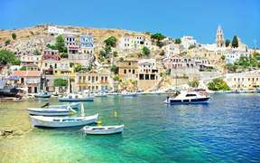
Symi
 The island of Symi is part of the Dodecanese archipelago, in the Aegean Sea. Its surface area is 65.75 km and it has 2,560 permanent inhabitants. It is a 2-hour boat ride from the port of Rhodes, 41 km away, and is appreciated for its authentic charm, turquoise waters and luxury. Traditional Greek life is present.
The small two-storey houses in pastel colors and colorful stolen are neoclassical, Italian-style. Symi is one of the most beautiful islands of the Dodecanese and is even considered to be the most beautiful.
According to mythology, Symi obtained its name from the princess of Rhodes, who fled to Symi with the god Glaucos because his father, the king, did not approve of his marriage.
The island is mountainous and the interior is dotted with small valleys. Its coastline alternates cliffs and creeks.
The capital, Symi, is located on the northeast coast and comprises the majority of the inhabitants of the island. In addition to its many historic places, the island is popular with tourists for its secluded beaches accessible only by the sea. The city is dominated by a fort that is accessed by 500 steps. A road leads from the port (at the end of the island) to the monastery of Panormitis. This is the second monastery of the Dodecanese after that of Patmos and is dedicated to the archangel Michael. It is the most important site of the island. There are two museums to see at the Monastery: a Lao graphic museum and a religious museum.
In Ano Symi you can see the old Castle of the Knights and visit the archaeological museum.
The island is surrounded by many small islands and islands nearby: Nymos, Chondros, Plati, Ghi, Koupi, Megalonisi, Karavalonisi, Marmaras, Pano Nero, Seskli, Strogglios,…
Symi has very beautiful beaches. Pedi, Agios Giorgios, Agia Marina, Diavates, Nimos and Hondros are considered the most beautiful.
Tilos
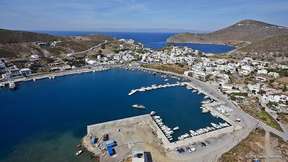
 Tilos is a Greek island, south of Nissiros and north of Chaliki, part of the Dodecanese archipelago in the Aegean.
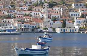
Tilos is an arid and mountainous island of 65 km. The population is 780 inhabitants and is concentrated in the two main villages of the island: Megalo Chorio, located inland and seat of the town hall of the island, and Livadia where most of the island is located, Tourist activity of the island. Other hamlets exist in different parts of the island.
Livadia is the main port of the island. Most residents are engaged in tourism or agriculture. The port is located 7 km south of Megalo Chorio, the capital.
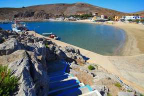
Traditional houses are set in the green valley, around the natural bay, hemmed by a beautiful white pebble beach bordered by Tamaris. The beach of Livadia is known for its crystal clear waters. It extends to Agios Stefanos, which was the ancient port during the Middle Ages. The church of Agios Nikolaos is also worth a visit.
Megalo Chorio, the capital of the island, is located inland in the north of the island. It is built in amphitheater, on a hillside. Its white houses are dominated by a Venetian fortress, built by the Hospitallers of Saint John. Megalo Chorio includes the location of the ancient city, as can be seen in the vestiges still visible between the houses. Within the Town Hall, one can find a collection with objects taken from the excavations carried out on the island. The church of the archangel Michael, the most famous of the island, deserves a visit.
One of the main attractions of the island is the Tilos park where the fauna and flora are impressive in many places. The Charkadio Cave is another interesting place. Next to the cave, visit the museum filled with prehistoric vestiges, where fossilized bones of elephants, deer and turtles of 70,000 years are exposed.
The monastery of Agios Panteleimon dating from the 15th century is abandoned but offers a splendid view to the sunset. It contains interesting paintings and icons.
Micro Chorio is a small village of 200 houses completely abandoned. In the evening, the ruins are illuminated.
Eristos is the largest beach on the island. It is considered the most beautiful of Tilos and is not far from Megalo Chorio. The beach of Agios Antonios has petrified remains of human skeletons. These were the remains of seamen trapped in the eruption of the Nissyros volcano in 600 BC. The beach of Plaka in the bay of Agios Antonios is special because of its eucalyptus and peacocks that parade.
Lethra is a small pebble beach with crystal clear waters and Skafi, Tholos and Agios Sergios are pretty small beaches, accessible by boat from Livadia.