Ionian islands
Corfu
 Corfu (or Kerkyra in Greek) is an island located in the Ionian Sea, on the western side of Greece, near its border with Albania. It is the capital of the periphery of the Ionian Islands. With a surface area of 592 km, it is one of the largest Greek islands and has a population of 107,600. The Italian footprint is very pronounced.
The island is known in the history of ancient Greece as a Greek city under the name of Corcyra. In mythology, Corcyra was a nymph, daughter of the river Asopos and the river-nymph Métope. Poseidon, having fallen in love with her, would have taken her to that island. Phoeax was born of their loves.
Being the greenest of the Greek islands, Corfu boasts three million olive trees, a flowery countryside and Adriatic-style villages. The island of Corfu offers splendid coastal landscapes and excellent secluded beaches. The island includes many interesting places to explore and many sights to see.
The old town of Corfu is the tourist heart of the island. This labyrinth with narrow streets is called locally ‘Kantounia’.
Unlike the Cyclades, the houses are mostly of neoclassical style with ocher and yellow facades and shutters painted green. They date back to the Venetian period. The streets and alleys are paved. The capital of the island is built around the Spianada, the great esplanade (one of the most beautiful squares in Greece), situated between the old citadel and the historical center, crossed by Voulgareos Street, extended by Avenue G. Theotoki.
The historic center of Corfu was declared World Heritage by UNESCO. The majestic buildings of neoclassical influence will please you: the palace of Saint Michael and Saint George, the arcades of the Liston, the Readers’ Society, the catholic cathedral, the Maitland rotunda, the Ionian parliament, the family manor of the Kapodistrias.
The main activity of the island is agriculture, despite the considerable development of tourism. The trees cover almost 60% of the total area and are mostly olive trees, orange and lemon trees, fruit trees and vines. The Kumquat has become the tourist symbol of the island. This small Chinese orange is grown only here and in Sicily and nowhere else in Europe.
Kouloura is a pretty fishing port that owes its name to the shape of its bay (ring-shaped biscuit). This place is charming and quiet. At 50 m is the pretty quiet beach of Kalami. This part of the coast (between Barbati and Kassiopi) shelters many beautiful coves.
Nissaki is a hamlet that houses a small picturesque beach.
Paleokastritsa is located on the north-western coast of Corfu, 25 km from the airport and the city of Corfu. Long considered one of the most beautiful villages in Corfu, it is one of the island’s most inescapable places with its small coves with turquoise and crystalline waters.
Sidari is one of the most popular seaside resorts on the island. It is said that if you bathe in the Channel of Love of Sidari, you will meet your soul mate. In Sidari, you will find two other impressive sandy beaches with sandstone formations.
The monastery of Kanoni located to the south of the city of Corfu, is the typical postcard, emblematic of the island. It is accessible by a dike that connects the main island to Kanoni. Kanoni is a renowned site for the view it offers to visitors. To avoid the mass of tourists, it is better to go very early in the morning. Off Kanoni is the islet surmounted by the monastery of Vlacherna. Further on is Pontikonissi, with its Pantocrator church.
It is this small corner of land (Mouse Island), which is probably the best known symbol of Corfu, which according to legend would be the mythical ship of Ulysses, which Poseidon transformed into stone, as Homer tells In the Odyssey.
The small town of Kassiopi is also home to many picturesque coves.
The beach of Glyfada is among the most beautiful on the island. At 6 km north-west of Glyfada lays the seaside hamlet of Ermones, situated in a protected cove with wild beauty.
The Achilleion or Sissi Palace is a neo-classical Pompeian-style palace located on the outskirts of the village of Gastouri in the municipal district of Achilleio. It is located about ten kilometers southwest of the city of Corfu, at the top of a hill at 145 meters above sea level. Built in 1889-1891 in honor of the Homeric hero Achilles by the Empress Elizabeth of Austria-Hungary (better known as Sissi), it was bought by the Kaiser Wilhelm II of Germany in 1907 and then occupied by the French and Serbian troops, making it a military hospital during the First World War.
Cephalonie
 Cephalonia or Kefalonia is a Greek island of the Ionian Sea famous for its abysses. Its size is 935 km2 and the current population density is 36 inhabitants per square kilometer. It is the largest and most mountainous of the Ionian Islands. Its highest point, Mount Enos, reaches an altitude of 1,626 meters.
Argostoli is the capital of the island. It is a pretty picturesque town of 16,000 inhabitants. It comprises more than a third of the inhabitants of the island. The capital lies on the hills that surround the lagoon of Koutavos and is the main port and the island. The area has been inhabited since 1600 and, in 1757, the dominant Venetians of Cephalonia decided to transfer to Argostoli the capital, which until then was the castle of St. George.
Argostoli had a large number of Venetian monuments that were destroyed by the earthquake of 1953. Since its reconstruction, it no longer has its local color or its ancient charm. The Valianou square, which is the central square of the city, is surrounded by cafes and restaurants. The pedestrian street of Lithostroto is the most commercial street on the island. Not far from here, the church of Spyridon has a beautiful carved wooden iconostasis. There are also many museums in the capital.
The lighthouse of Agios Theodoris, near the city, is one of the symbols of the island. It was built in 1829 by the English governor Napier.
Lixouri is the second largest city. It is located 30 km west of Argostoli. It is the main city of the Paliki region, and was built on the site where the ancient city of Pali was located, one of the four main cities of Kefalonia during Antiquity. Lixouri lies in the most flat and fertile area of Cephalonia. The city has 3000 inhabitants, most of whom are engaged in agriculture and tourism.
Plateia Petritsi’s main square is surrounded by many old-fashioned cafés. From this square, a pedestrian street full of shops begins.
Most of the inhabitants of Lixouri are famous for their musical talents. There is also a philharmonic school which is one of the most important in Greece.
Lixouri was almost completely destroyed during the 1953 earthquake but was carefully reconstructed in the traditional style. A walk through the village will lead you to discover ancient churches with beautiful frescoes, an archaeological museum, neoclassical buildings and the famous monastery of Kipoureon.
Lixouri has no beach in the city, but just outside it is Lepeda, frequented by tourists and locals. To get there from Lixouri, you have to follow the sea to the south for a mile and a half. It is a beautiful wide, red and sandy beach, not too different from the Xi beach which is famous and much more crowded.
Xi is located in the south of the Paliki Peninsula, in the Mantzavinata district, near Lixouri. It is a beautiful sandy beach which extends 4 km, famous for its soft and red sand.
Assos is an authentic village located in the north-west of the island, 30 km from Argostoli, on an isthmus, near a Venetian fortress. It is one of the most picturesque villages of Kefalonia. Not far from the village, the bay of Myrtos shelters one of the most beautiful beaches of the island. The sand is white and its turquoise waters.
The cave of Melisani, north-west of Sami, about 5 km from Argostoli, is worth a visit. It is 50 m long and 35 m wide and about 30 m deep. The cave is about 500 m from the sea and the water from the lake is 1 m above sea level. It was revealed when its roof collapsed during the 1953 earthquake.
The lake inside the cave is a mixture of fresh water and sea water. The cave is B-shaped and is in two parts. The ceiling of the cave is opened in one of them, one can see the sky. In the other part, lighted by electricity, the ceiling presents stalactites, some of which have the form of a dolphin. The lake is of a beautiful color changing according to the rays of the sun from turquoise to indigo or violet, with better effect towards noon when the sun gives directly on the waters, with a background covered with stones. The rocks of the walls are light brown to pale pink. Vegetation, including trees, grows to the edge of the lake.
Ithaque
 Ithaca (Ithaki) is an island in the Ionian Sea, west of mainland Greece and northeast of Kefalonia. It has nearly 3 200 inhabitants for an area of 96 km. It is a verdant island with crystal clear waters. The island is full of bays and capes. The east coast has rather steep and rugged cliffs while the west coast is lower and green. Ithaca is mountainous with a peak culminating at 780 meters, Mount Niritas.
According to Homer’s Odyssey, Ulysses was the king of Ithaca, an island he recovered after having long wandered at sea after having undergone numerous trials. It was at Ithaca that his wife Penelope waited for him despite some enterprising pretenders, such as Antinous.
It was in Deka Bay that Ulysses was laid asleep. The source of Arethousa, in the south is accessible in about 2 hours of walk. It was there that Ulysses, disguised as a beggar, met Eumaeus. It is assumed that the palace of Ulysses was situated in the neighborhood of Stavros.
The island has two ports: Vathy and Piso Aetos. There are no moorings available in these ports but it is possible to anchor at Frikes, Kioni and Vathy although most boaters prefer to moor at dock. Vathy is the main port. Vathy is also the capital of the island and the largest village of Ithaca. It is a picturesque village of about 2000 inhabitants.
It is built amphitheatrically around the largest natural harbor in Greece. On either side of the narrow entrance to the port are the ruins of a French fort built in 1807 to protect itself from the English fleet.
The earthquakes of 1953 almost completely destroyed the village, leaving behind some ruins and very few buildings intact. Fortunately, most of the Venetian buildings that were demolished were rebuilt in the same style, which allowed Vathy to retain its traditional architecture. Moreover, throughout the island, since a law passed in 1978, it is forbidden to build in a different style from the traditional architectural style.
The monastery Panagia ton katharon, in Kathara, is opened to visitors. It is the place of pilgrimage of the inhabitants of the island and is endowed with beautiful icons, as well as beautiful landscapes.
There are also some ancient ruins just outside Stavros.
Most of the beaches on Ithaca offer round and white pebbles and crystal clear waters.
Leucade
 Lefkada (Lefkada) is one of the Ionian Islands. For a long time it was called Saint Maura.
North of Ithaca and Kefalonia, it has an area of 305 km2 for a coastline of 117 km. Its summit, Mount Stavrota, amounts to 1,158 meters.
The main cities are the capital (Lefkada), Nydri and Vassiliki (ports to the islands of Meganissi and Kefalonia). The main activities of the island are agriculture (oil and wine), livestock and tourism.
Lefkada is a mountainous island with rich vegetation to the east and south. The island was connected to the continent of which it was for a long time a peninsula.
To the east, the ribs are soft, sheltered from the wind and punctuated by small green islets, of which the best known are Skorpios, Madouri and Sparti. The eastern region is verdant. There are small maritime villages, such as Ligia and Nikiana, and Nidri, one of the most touristic sites on the island. The vestiges of a prehistoric city and circular tombs of the same period, discovered in the surrounding area, persuaded the German archaeologist Dörpfeld that this was the home of Ulysses.
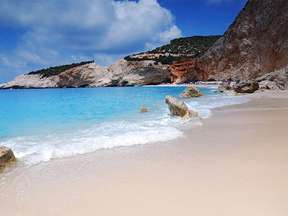
Its western coasts, on the other hand, are steep and intersected by large golden sandy beaches.
Lefkada owes its name to its white chalk cliffs which lie to the south of the island: the Cape of the Lady (72 meters high).
The west coast of Lefkada has long sandy beaches below impressive cliffs, while on the east coast there are more sheltered bays and coves.
Porto Katsiki, the south of the island is considered by many as the most beautiful beach of Lefkada but also as one of the most beautiful in Greece. It is located 40 kilometers southwest of the capital of the island and is reached by a staircase that descends on a beautiful beach of small pebbles, carved into the chalky cliffs. This is one of the main attractions of the island. Porto Katsiki owes its fame to the enchanting landscape and especially to its crystal clear blue waters and its sandy beach.
Egremni is located in the south-west of the island, about 30 km from the capital. It is considered one of the most beautiful beaches of the island and also of the Mediterranean. This beach is also one of the most popular tourist destinations in Greece and throughout Europe. Famous for its remarkably blue and clear waters, Egremni beach is one of the longest beaches of Lefkada, stretching over 2.5 km. Egremni is surrounded by cliffs and is therefore not as easily accessible. The nearest village is the village of Athani, located a few kilometers to the north.
Meganissi
 Meganissi is an Ionian island of 22 km which is separated by a strait just 800 meters from Lefkada.
The population of the island has about 1,000 inhabitants divided between the two port villages of Vathi and Spartochori and the inland village of Katomeri.
Meganissi has 4 villages: Spilia and its port, spartohori to the traditional houses, Vathi and Katomeri.
In spite of the sailing boats which come to dock there, Meganissi has preserved its authenticity. The port of Vathi has some taverns. You can swim there, but you will find the most beautiful beaches in Limenari (east coast) and Agios Ioannis (west coast). In the south, on the narrow peninsula to Cape Kefali, the Papanikolis cave is accessible either by foot or by a tour boat from Nidri. You will visit on foot the villages of Katomeri and Spartohori.
Parga
 Parga located in Epirus, on the west coast of Greece, on the Ionian Sea. It has a population of just over 2,000 and extends over 276.5 km.
Located in a double creek, Parga was Venetian from the 15th to the end of the 19th century. In the 19th century, it was owned by Ali Pasha. Today it is a seaside resort.
Parga is 49 km south of the town of Igoumenitsa and 67 km north of the city and Preveza airport. Outside the city are the islands of Paxos and Antipaxos which can be seen in good weather.
Its typical architecture of the Greek islands, its position by the sea and its picturesque trails will remind you of the landscape of the islands in Greece.
A Venetian fortress dominates the city. It was built in the 16th century. You will be able to see the remains of a wall at the foot of the enclosure of the castle. A little further on the banks of the river Acheron you can go for river trips or take archeology lessons in the Necromanteion of Efira, the parlor of the dead. The archaeological site near Messopotamos is one of the most famous attractions of the region.
The ecclesiastical museum which is located in the city center, next to the church of Saint Apostoles deserves a visit. It contains copies of scripts written by a monk in the 16th century, two 17th century bibles, and many icons paintings. You can also discover a Mycenaean vaulted tomb outside the city.
The small fishing village of Syvota, known since the sixties for the beauty of its beaches, is appreciated by celebrities from all over the world.
On the mountain to the east of Syvota, nestles a plateau where is the abandoned village of Vrachonas. It is composed of about fifty stone dwellings. The ruins of its prehistoric acropolis testify to the ancient history of the region.
Turquoise waters, fine sand, pebbles and verdant hills… Its ribs are perfect for sports and underwater explorations.
A motor boat is ideal to discover and enjoy the coasts and the many coves of Parga.
The beach of Kryoneri is the best known of the island and overlooks the small island of Panagia. To the south, the beach of Piso Kryoneri a small creek is bordered in large part by sand. The long beaches of Valtos and Lichnos are quite touristy but very pleasant.
More difficult to access, the beach of Agianakis, much more to the south, is less frequented. The water is turquoise. Conversely, Sarakiniko beach, north of Parga, is quite long and busy, but it remains one of the most beautiful in the city. It is located 12 km from Parga, after the village of Agia and is also accessible by boat from the quay of Parga. Crystal clear waters and an olive grove compose a unique landscape.
Paxos
 Paxos is part of the Ionian Islands. It is located 14 km south of Corfu. Paxos is a very small island covered with olive trees, set with impressive beaches and cliffs at the foot of which are hidden many marine caves.
The area of Paxos is 25 km and it has about 3000 inhabitants. Its highest point is 248 m above sea level. It is the smallest of the Ionian Islands and is renowned for its excellent olive oil.
According to Greek mythology, Poseidon would have separated Paxos from Corfu with his trident to create a refuge sheltering his loves: the god of the sea had just convinced Amphitrite to become his wife.
The capital of Paxos is Gaios, a picturesque village built around a fishing port protected by two advanced islets, Agios Nikolas and Panagia. Half the inhabitants of the island live there. On the north side is the village of Lakka and to the east is the charming village of Loggos.
2.5 km south of Paxos is its neighboring Antipaxos, a small uninhabited island (5 km) with the most beautiful beaches in the area and products of wine. You will also find two beautiful beaches, Vrika and Voutoumi. The sand is thin and the sea clean.
The beaches:
– Lakka Bay: turquoise and shallow sea at Harami and Kanoni, north of Paxos
– Orkos: transparent waters, 1k southeast of Lakka
– Lakkos: pebble cove encircled with small white rocks and pines, east of Paxos between Lakka and Loggos
– Monodendri: One of the largest and most popular beaches in Paxos, in the east, 1km north of Loggos
– Mongonissi: The only sandy beach of Paxos, in the South
– Erimitis: White rocks, turquoise waters, small pebble beach, beautiful landscape
– Kipiadi: Long stretch of pebble beach, transparent waters, 1km south of Logos
Preveza
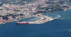 Preveza or Preveza is a town in the north-west of Greece, at the mouth of the Ambracian Gulf. It is the chief town of the regional district of Preveza, in the outskirts of Epirus. It has 19,050 inhabitants and covers 381.6 km. It is both a seaside resort and a small industrial port.
Natural beauties, rare biotopes, the enchanting Ziros Lake, ancient monuments, and lush vegetation are the assets of the region. The city was elected by writers and poets, like Marc-Aurelius and Karyotakis, to devote themselves to their art.
The Seitan Bazar and the Archaeological Museum, the Venetian Tower with the Solar Clock, next to the church of Agios Haralambos with its carved wooden iconostasis and that of Agios Athanassios and its icons of 1780 are also worth visiting. Above, you can see the fort of Pandokrator with the chapel that houses it, built in 1807 by Ali Pacha of Ioannina, to control the entrance of the Gulf.
The capital, Preveza, was founded in the late 12th century after the devastation of Nicopolis. Today it is the center of the financial and administrative activity of the region. The city is built exactly at the mouth of the Ambracian Gulf, fed by the delta systems of the Louros River and the Arachthos River. There is a shallow water lagoon system, including a rare ecosystem protected by the Ramsar Convention on Wetlands. The city has recently been connected to Aktion in the neighboring department by a road tunnel.
The narrow pedestrian streets, old style and neoclassical buildings are some of the features of Preveza. You can visit the monuments scattered in the city, the Byzantine churches, Venetian and Ottoman castles, the ruins of the Roman city of Nicopolis and the ancient Kassiopi, the Necromantium of the Acheron, the most important ancient times, Zalongo The place of sacrifice, and the romantic castle of Parga.
Nicopolis (city of victory) was founded in 31 before JC by Octavian, later Emperor Augustus, in celebration of his victory against Antony and Cleopatra at the naval battle of Aktion. The Byzantine emperor Justinian strengthened his defense by rebuilding his walls, which you can still explore today.
Alonaki is a beach with crystal clear waters and fine sand. It is a beautiful natural place near the community of Valanidorrachi and is located halfway between Preveza and Igoumenitsa.
Zakynthos
 Zakynthos is the third largest island in the Ionian Islands. It is a little over 400 km2 and has 42,000 inhabitants. Its highest point is 756 m. It is a fertile island, mainly covered with mountains and hills.
Zakynthos was first annexed to Greece in 1864 after having been under Venetian, French and British domination; it was first called Zante by the Italians, then ‘Fior di Levante’ (Levante’s flower) and ‘Isola d ‘oro’.
After the earthquake of 1953, the island was rebuilt, and the old Venetian buildings, neoclassical monuments and 19th century churches were restored.
The capital bears the same name. It is a pleasant city, respecting the architecture of its past. The Place Agiou Marcou is the most beautiful of the city. There are three beautiful churches that resisted the 1953 earthquake.
The island is one of the most beautiful and popular of the Ionian Sea. It is world famous for its sandy beaches, especially Laganas in the south of the island, where the sea-turtles “Caretta Caretta” are protected. The beaches of Zakynthos are the habitat and most important spawning places of the “Caretta Caretta” of all the Mediterranean area. Zante is also home to monk seals, another protected species.
The Zakynthos Marine National Park, established in 1999, is dedicated to the protection of the loggerhead turtle. The beaches of the island are the most important spawning places of this species in the Mediterranean. Each year, at the beginning of June, females arrive on the beaches of the south of the island to bury their eggs during the night. After about 55 days, the young turtles emerge from the eggs just before dawn and go to the sea.
Zakynthos is also known for its intense nightlife, making it a frequent destination for young people.
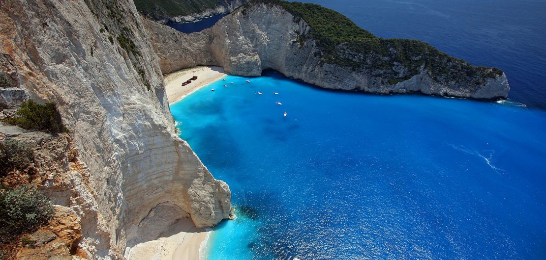
Navagio (Bay of Shipwreck), west of the island, is considered the jewel of Zakynthos and also as one of the most beautiful beaches in the world. The sand is gilded and the waters are of a dazzling turquoise. This creek owes its name to the ‘Panagiotis’, a boat that used to smuggle cigarettes and ran aground in 1983 at the foot of two cliffs a few dozen meters from the sea. It is a fascinating panorama due to its originality and natural sound.
On the eastern coast of Cape Skinari, in the northern part of the island, are the Blue Caves. A series of geological formations have created this marine landscape. Natural arcs have been excavated by erosion. These caves are famous for the deep blue color of the water lit by the sunlight, reflecting in the water.
The Venetian citadel, perched on the Bokali hill, offers a breathtaking view of the sea and the interior of the island.
The Agios Dionysos Church, founded in 1708 with its Byzantine and Western architecture, is worth a visit.
At the Post-Byzantine Arts Museum you can admire a collection of beautiful post-Byzantine icons, 16th-century wooden sculptures and 12th-century murals.
The museums of two writers of the city are also worthy of attention: the museum Grigorios Xenopoulos and the museum of Dionysos Solomos.
In the south of the island you will find the islets of Strofades. On one of them stands the impressive monastery of Agios Dionysos, built in the 13th century.
There are many beaches on the island, most of the beaches equipped, offer water sports.
Porto Zorro is an excellent place for diving; you will find a well-appointed beach. A little further on, Bananas beach that attract young people.
Not far from Lake Keri, there is a small beach facing the island of Marthonissos and close to Xirokastro: the beaches of Daphne and Sekania.
Kalamaki, Gerakas, Porto Roma, Agalas are other examples of beautiful beaches in Zakynthos.